|
search place name
|
||
Chattisham (United Kingdom)Chattisham is a town in United Kingdom. An overview map of the region around Chattisham is displayed below.
regional and 3d topo map of Chattisham, United Kingdom ::

Chattisham airports ::
The nearest airport is BEQ - Honington, located 39.3 km north west of Chattisham.
Other airports nearby include MHZ - Mildenhall (53.1 km north west), SEN - Southend (56.9 km south west), STN - London Stansted (58.4 km west), CBG - Cambridge (62.9 km west), Nearby towns ::
Hintlesham (1.9km north) //
Burstall (2.2km north east) //
Capel Saint Mary (3.9km south) //
Copdock (3.4km east) //
Belstead (3.9km south east) //
Sproughton (3.9km north east) //
Bentley (6.0km south) //
Bramford (5.0km north east) //
Somersham (7.4km north) //
Raydon (4.9km west) //
Aldham (4.9km west) //
East Bergholt (7.8km south) //
Offton (7.8km north) //
Claydon (7.2km north east) //
Great Blakenham (8.2km north east) //
[all distances 'as the bird flies' and approximate] 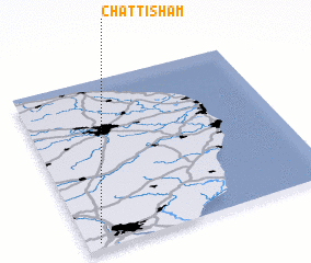 Places with similar names to Chattisham, United Kingdom ::
// Shatshamba (CD)
// Shatshombo (CD)
// Shatshombo (CD)
// Chŏtch'imi (KP)
// Chettisham (GB)
// Shottisham (GB)
Disclaimer :: Information on this page comes without warranty of any kind |
||
|
Where is Chattisham? Elevation and coordinates ::
Latitude (lat): 52°2'0"N Longitude (lon): 1°3'0"E
Elevation (approx.): 51m (map arrows pan, magnifying glasses zoom) |
||
|
Visiting Chattisham? Hotel/Accommodation ::
Book a hotel in Chattisham Travel Guide ::
rental cars ::
car rental offers GPS waypoint ::
download a GPX waypoint (PoI) of Chattisham for your GPS receiver
|
||