|
search place name
|
||
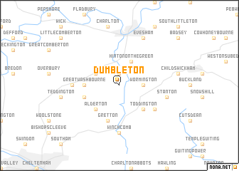
Dumbleton (United Kingdom)Dumbleton is a town in United Kingdom. An overview map of the region around Dumbleton is displayed below.
regional and 3d topo map of Dumbleton, United Kingdom ::
Dumbleton airports ::
The nearest airport is GLO - Golouchestershire Gloucestershire, located 19.4 km south west of Dumbleton.
Other airports nearby include FFD - Fairford (39.2 km south), BZZ - Brize Norton (39.7 km south east), OXF - Oxford Kidlington (48.8 km south east), BHX - Birmingham (50.9 km north), Nearby towns ::
Sedgeberrow (1.9km north) //
Wormington (2.3km east) //
Ashton under Hill (2.9km north west) //
Hinton on the Green (3.9km north) //
Alderton (4.4km south west) //
Toddington (4.4km south east) //
Great Washbourne (3.4km west) //
Gretton (5.7km south) //
Little Washbourne (3.9km south west) //
Stanway (5.0km south east) //
Beckford (4.6km west) //
Winchcomb (7.4km south) //
Stanton (4.9km east) //
Bengeworth (7.8km north) //
Evesham (7.8km north) //
[all distances 'as the bird flies' and approximate] 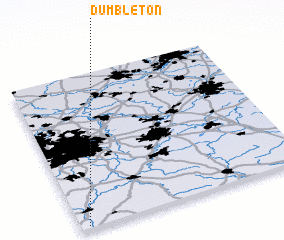 Places with similar names to Dumbleton, United Kingdom ::
// Tumbleton (US)
// Tambilidan (MY)
// Tamaleton (MX)
// Dummalatenna (LK)
// Tamalo Town (LR)
// Dumbleton (AU)
Disclaimer :: Information on this page comes without warranty of any kind |
||
|
Where is Dumbleton? Elevation and coordinates ::
Latitude (lat): 52°1'0"N Longitude (lon): 1°58'0"W
Elevation (approx.): 57m (map arrows pan, magnifying glasses zoom) |
||
|
Visiting Dumbleton? Hotel/Accommodation ::
Book a hotel in Dumbleton Travel Guide ::
rental cars ::
car rental offers GPS waypoint ::
download a GPX waypoint (PoI) of Dumbleton for your GPS receiver
|
||