|
search place name
|
||
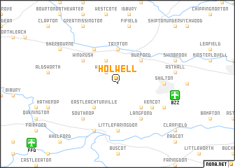
Holwell (United Kingdom)Holwell is a town in United Kingdom. An overview map of the region around Holwell is displayed below.
regional and 3d topo map of Holwell, United Kingdom ::
Holwell airports ::
The nearest airport is BZZ - Brize Norton, located 6.0 km east of Holwell.
Other airports nearby include FFD - Fairford (12.7 km south west), OXF - Oxford Kidlington (25.2 km east), LYE - Lyneham (36.9 km south west), GLO - Golouchestershire Gloucestershire (37.3 km north west), Nearby towns ::
Westwell (2.2km north west) //
Little Barrington (3.9km north) //
Burford (4.4km north east) //
Eastleach (4.4km south west) //
Eastleach Martin (4.4km south west) //
Eastleach Turville (4.4km south west) //
Broadwell (4.4km south east) //
Taynton (5.6km north) //
Windrush (5.1km north west) //
Great Barrington (6.0km north) //
Kencot (5.1km south east) //
Langford (6.0km south) //
Little Faringdon (7.4km south) //
Shilton (4.6km east) //
Southrop (6.5km south west) //
Lechlade (7.8km south) //
Alvescot (5.9km south east) //
[all distances 'as the bird flies' and approximate] 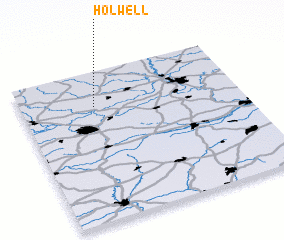 Places with similar names to Holwell, United Kingdom ::
Disclaimer :: Information on this page comes without warranty of any kind |
||
|
Where is Holwell? Elevation and coordinates ::
Latitude (lat): 51°46'0"N Longitude (lon): 1°40'0"W
Elevation (approx.): 125m (map arrows pan, magnifying glasses zoom) |
||
|
Visiting Holwell? Hotel/Accommodation ::
Book a hotel in Holwell Travel Guide ::
rental cars ::
car rental offers GPS waypoint ::
download a GPX waypoint (PoI) of Holwell for your GPS receiver
|
||