|
search place name
|
||
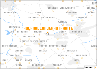
Hucknall under Huthwaite (United Kingdom)Hucknall under Huthwaite is a town in United Kingdom. An overview map of the region around Hucknall under Huthwaite is displayed below.
regional and 3d topo map of Hucknall under Huthwaite, United Kingdom ::
Hucknall under Huthwaite airports ::
The nearest airport is EMA - Nottingham East Midlands, located 33.7 km south of Hucknall under Huthwaite.
Other airports nearby include WTN - Waddington (52.1 km east), MAN - Manchester (69.6 km west), QCY - Coningsby (76.1 km east), HUY - Humberside (80.0 km north east), Nearby towns ::
Teversal (2.2km north east) //
Tibshelf (2.2km west) //
Blackwell (2.9km south west) //
Sutton in Ashfield (2.9km south east) //
South Normanton (4.3km south west) //
Skegby (3.3km east) //
Hardstoft (3.3km west) //
Ault Hucknall (5.6km north) //
Pinxton (5.7km south) //
Kirkby in Ashfield (6.0km south) //
Pleasley (5.0km north east) //
Selston (7.5km south) //
Westhouses (4.8km south west) //
Pilsley (4.8km north west) //
East Kirkby (6.5km south east) //
Holmewood (6.5km north west) //
Heath (7.7km north) //
[all distances 'as the bird flies' and approximate] 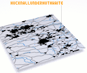 Places with similar names to Hucknall under Huthwaite, United Kingdom :: Disclaimer :: Information on this page comes without warranty of any kind |
||
|
Where is Hucknall under Huthwaite? Elevation and coordinates ::
Latitude (lat): 53°8'0"N Longitude (lon): 1°18'0"W
Elevation (approx.): 193m (map arrows pan, magnifying glasses zoom) |
||
|
Visiting Hucknall under Huthwaite? Hotel/Accommodation ::
Book a hotel in Hucknall under Huthwaite Travel Guide ::
rental cars ::
car rental offers GPS waypoint ::
download a GPX waypoint (PoI) of Hucknall under Huthwaite for your GPS receiver
|
||