|
search place name
|
||
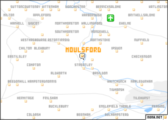
Moulsford (United Kingdom)Moulsford is a town in United Kingdom. An overview map of the region around Moulsford is displayed below.
regional and 3d topo map of Moulsford, United Kingdom ::
Moulsford airports ::
The nearest airport is BBS - Blackbushe, located 31.4 km south east of Moulsford.
Other airports nearby include OXF - Oxford Kidlington (35.8 km north), ODH - Odiham (36.3 km south east), BZZ - Brize Norton (38.5 km north west), FAB - Farnborough (38.7 km south east), Nearby towns ::
Streatley (1.9km south) //
South Stoke (1.2km east) //
Goring (2.2km south east) //
Cholsey (3.7km north) //
Basildon (4.4km south east) //
North Stoke (4.4km north east) //
South Moreton (6.0km north) //
Mongewell (6.0km north) //
Aldworth (5.1km south west) //
Aston Tirroid (5.1km north west) //
Sotwell (7.4km north) //
Ipsden (5.0km east) //
Wallingford (7.5km north) //
Crowmarsh Gifford (6.5km north east) //
North Moreton (7.8km north) //
Pangbourne (7.2km south east) //
Whitchurch (7.2km south east) //
Tidmarsh (8.7km south east) //
[all distances 'as the bird flies' and approximate]  Places with similar names to Moulsford, United Kingdom :: Disclaimer :: Information on this page comes without warranty of any kind |
||
|
Where is Moulsford? Elevation and coordinates ::
Latitude (lat): 51°32'0"N Longitude (lon): 1°9'0"W
Elevation (approx.): 59m (map arrows pan, magnifying glasses zoom) |
||
|
Visiting Moulsford? Hotel/Accommodation ::
Book a hotel in Moulsford Travel Guide ::
rental cars ::
car rental offers GPS waypoint ::
download a GPX waypoint (PoI) of Moulsford for your GPS receiver
|
||