|
search place name
|
||
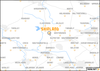
Shirland (United Kingdom)Shirland is a town in United Kingdom. An overview map of the region around Shirland is displayed below.
regional and 3d topo map of Shirland, United Kingdom ::
Shirland airports ::
The nearest airport is EMA - Nottingham East Midlands, located 32.1 km south of Shirland.
Other airports nearby include WTN - Waddington (58.9 km east), MAN - Manchester (64.1 km north west), BHX - Birmingham (77.4 km south), QCY - Coningsby (82.7 km east), Nearby towns ::
Morton (2.2km north east) //
Stretton (2.2km north west) //
Alfreton (2.2km south east) //
Westhouses (2.2km east) //
Clay Cross (3.9km north) //
Pilsley (4.3km north east) //
South Wingfield (4.3km south west) //
Swanwick (5.6km south) //
Hardstoft (3.8km north east) //
Blackwell (4.4km east) //
Tibshelf (4.8km north east) //
South Normanton (4.8km south east) //
Pentrich (7.5km south) //
Holmewood (8.1km north east) //
[all distances 'as the bird flies' and approximate]  Places with similar names to Shirland, United Kingdom ::
// Cherryland (US)
// Shirland (US)
// Shoreland (US)
// Shoreland (US)
// Sharyland (US)
// Shorāh Lāndi (PK)
Disclaimer :: Information on this page comes without warranty of any kind |
||
|
Where is Shirland? Elevation and coordinates ::
Latitude (lat): 53°7'0"N Longitude (lon): 1°24'0"W
Elevation (approx.): 131m (map arrows pan, magnifying glasses zoom) |
||
|
Visiting Shirland? Hotel/Accommodation ::
Book a hotel in Shirland Travel Guide ::
rental cars ::
car rental offers GPS waypoint ::
download a GPX waypoint (PoI) of Shirland for your GPS receiver
|
||