|
search place name
|
||
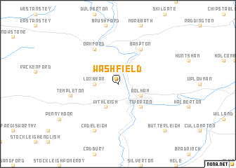
Washfield (United Kingdom)Washfield is a town in United Kingdom. An overview map of the region around Washfield is displayed below.
regional and 3d topo map of Washfield, United Kingdom ::
Washfield airports ::
The nearest airport is EXT - Exeter, located 23.3 km south of Washfield.
Other airports nearby include CWL - Cardiff (53.0 km north), YEO - Yeovilton (62.2 km east), PLH - Plymouth (70.4 km south west), BRS - Bristol (74.9 km north east), Nearby towns ::
Stoodleigh (2.2km north west) //
Loxbear (2.3km west) //
Withleigh (3.9km south) //
Bolham (3.0km south east) //
Tiverton (4.4km south east) //
Oakford (6.0km north west) //
Bampton (6.0km north east) //
Templeton (5.0km west) //
Cadeleigh (7.8km south) //
Butterleigh (8.8km south east) //
[all distances 'as the bird flies' and approximate] 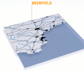 Places with similar names to Washfield, United Kingdom ::
// Wachfeld (DE)
Disclaimer :: Information on this page comes without warranty of any kind |
||
|
Where is Washfield? Elevation and coordinates ::
Latitude (lat): 50°56'0"N Longitude (lon): 3°31'0"W
Elevation (approx.): 160m (map arrows pan, magnifying glasses zoom) |
||
|
Visiting Washfield? Hotel/Accommodation ::
Book a hotel in Washfield Travel Guide ::
rental cars ::
car rental offers GPS waypoint ::
download a GPX waypoint (PoI) of Washfield for your GPS receiver
|
||