|
search place name
|
||
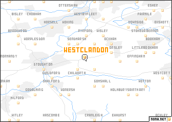
West Clandon (United Kingdom)West Clandon is a town in United Kingdom. An overview map of the region around West Clandon is displayed below.
regional and 3d topo map of West Clandon, United Kingdom ::
West Clandon airports ::
The nearest airport is FAB - Farnborough, located 19.5 km west of West Clandon.
Other airports nearby include LGW - London Gatwick (24.4 km south east), LHR - London Heathrow (25.5 km north), BBS - Blackbushe (25.6 km west), ODH - Odiham (31.0 km west), Nearby towns ::
East Clandon (2.2km south east) //
Merrow (2.2km south west) //
Ripley (3.9km north) //
Chilworth (3.9km south) //
Sendmarsh (3.9km north) //
Send (4.4km north west) //
Pyrford (5.6km north) //
Albury (5.7km south) //
West Horsley (3.9km north east) //
Gomshall (6.0km south east) //
Wisley (6.0km north east) //
Shere (6.0km south east) //
Ockham (5.1km north east) //
East Horsley (4.6km east) //
Woking (7.8km north) //
Wonersh (7.8km south) //
Guildford (5.9km south west) //
Shalford (7.2km south west) //
Bramley (8.2km south west) //
Horsell (8.7km north west) //
[all distances 'as the bird flies' and approximate]  Places with similar names to West Clandon, United Kingdom ::
// West Clinton (US)
Disclaimer :: Information on this page comes without warranty of any kind |
||
|
Where is West Clandon? Elevation and coordinates ::
Latitude (lat): 51°15'0"N Longitude (lon): 0°30'0"W
Elevation (approx.): 87m (map arrows pan, magnifying glasses zoom) |
||
|
Visiting West Clandon? Hotel/Accommodation ::
Book a hotel in West Clandon Travel Guide ::
rental cars ::
car rental offers GPS waypoint ::
download a GPX waypoint (PoI) of West Clandon for your GPS receiver
|
||