|
search place name
|
||
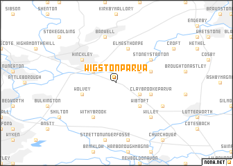
Wigston Parva (United Kingdom)Wigston Parva is a town in United Kingdom. An overview map of the region around Wigston Parva is displayed below.
regional and 3d topo map of Wigston Parva, United Kingdom ::
Wigston Parva airports ::
The nearest airport is CVT - Coventry, located 18.3 km south west of Wigston Parva.
Other airports nearby include BHX - Birmingham (29.8 km west), EMA - Nottingham East Midlands (36.9 km north), OXF - Oxford Kidlington (73.8 km south), BZZ - Brize Norton (85.4 km south), Nearby towns ::
Burbage (2.9km north west) //
Sharnford (2.9km north east) //
Claybrooke Magna (2.9km south east) //
Wibtoft (4.3km south east) //
Elmesthorpe (5.7km north) //
Wolvey (3.9km south west) //
Sapcote (3.9km north east) //
Claybrooke Parva (3.9km south east) //
Withybrook (6.0km south) //
Hinckley (5.0km north west) //
Stoney Stanton (5.0km north east) //
Barwell (7.5km north) //
Willey (6.5km south east) //
Ullesthorpe (5.8km south east) //
[all distances 'as the bird flies' and approximate] 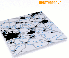 Places with similar names to Wigston Parva, United Kingdom :: Disclaimer :: Information on this page comes without warranty of any kind |
||
|
Where is Wigston Parva? Elevation and coordinates ::
Latitude (lat): 52°30'0"N Longitude (lon): 1°19'0"W
Elevation (approx.): 127m (map arrows pan, magnifying glasses zoom) |
||
|
Visiting Wigston Parva? Hotel/Accommodation ::
Book a hotel in Wigston Parva Travel Guide ::
rental cars ::
car rental offers GPS waypoint ::
download a GPX waypoint (PoI) of Wigston Parva for your GPS receiver
|
||