|
search place name
|
||
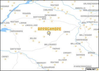
Arragh More (Tiobraid Árann, Ireland)Arragh More is a town in the Tiobraid Árann region of Ireland. An overview map of the region around Arragh More is displayed below.
regional and 3d topo map of Arragh More, Ireland ::
Arragh More airports ::
The nearest airport is GWY - Galway, located 66.7 km north west of Arragh More.
Other airports nearby include SNN - Shannon (71.9 km south west), NOC - Connaught (108.5 km north west), WAT - Waterford (115.9 km south east), DUB - Dublin (124.4 km east), Nearby towns ::
Moat Ville (1.3km west) //
Ballingarry (4.3km south) //
High Street (3.5km south west) //
Lelagh (5.4km north) //
Firville (3.6km north west) //
Pike (5.5km north) //
The Pike (6.1km south) //
Aglish (4.2km south west) //
Carrig (3.9km east) //
Rathcabban (6.7km north) //
Saint Kieranʼs (6.5km north) //
Lake Village (5.1km north west) //
Graigue (7.1km north) //
Coolross (8.8km north) //
Cangort (8.5km south east) //
Brookes Cross Roads (9.1km south) //
New Bridge (9.1km north east) //
Redwood (9.0km north west) //
[all distances 'as the bird flies' and approximate] 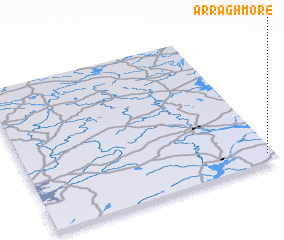 Places with similar names to Arragh More, Ireland :: Disclaimer :: Information on this page comes without warranty of any kind |
||
|
Where is Arragh More? Elevation and coordinates ::
Latitude (lat): 53°3'21"N Longitude (lon): 8°1'50"W
Elevation (approx.): 65m (map arrows pan, magnifying glasses zoom) |
||
|
Visiting Arragh More? Hotel/Accommodation ::
Book a hotel in Arragh More Travel Guide ::
Buy a travel guide for Ireland rental cars ::
car rental offers GPS waypoint ::
download a GPX waypoint (PoI) of Arragh More for your GPS receiver
|
||