|
search place name
|
||
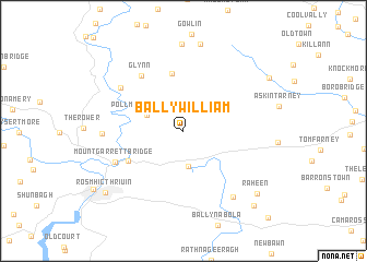
Ballywilliam (Loch Garman, Ireland)Ballywilliam is a town in the Loch Garman region of Ireland. An overview map of the region around Ballywilliam is displayed below.
regional and 3d topo map of Ballywilliam, Ireland ::
Ballywilliam airports ::
The nearest airport is WAT - Waterford, located 33.2 km south west of Ballywilliam.
Other airports nearby include DUB - Dublin (114.9 km north), ORK - Cork (130.5 km south west), NOC - Connaught (208.2 km north west), ENK - Enniskillen St Angelo (222.8 km north), Nearby towns ::
Barrack Village (2.3km north) //
Corcoranʼs Cross Roads (3.6km south) //
Pollmounty Bridge (2.8km north west) //
Ballycrinnigan (5.9km north) //
Ballyanne (4.6km south west) //
Glynn (6.2km north west) //
Mount Garrett Bridge (5.3km south west) //
Saint Mullins (5.9km north west) //
Tinnascolly (5.1km west) //
Old Ross (7.4km south east) //
Raheen (7.9km south east) //
New Ross (7.9km south west) //
Ros Mhic Thriúin (7.9km south west) //
Crooked Bridge (7.6km north east) //
Courthoyle (8.9km south east) //
Ballynagrallagh (10.3km south east) //
[all distances 'as the bird flies' and approximate] 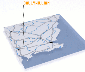 Places with similar names to Ballywilliam, Ireland ::
// Ballywilliam (IE)
Disclaimer :: Information on this page comes without warranty of any kind |
||
|
Where is Ballywilliam? Elevation and coordinates ::
Latitude (lat): 52°27'11"N Longitude (lon): 6°51'55"W
Elevation (approx.): 79m (map arrows pan, magnifying glasses zoom) |
||
|
Visiting Ballywilliam? Hotel/Accommodation ::
Book a hotel in Ballywilliam Travel Guide ::
Buy a travel guide for Ireland rental cars ::
car rental offers GPS waypoint ::
download a GPX waypoint (PoI) of Ballywilliam for your GPS receiver
|
||