|
search place name
|
||
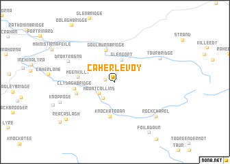
Caherlevoy (Limerick, Ireland)Caherlevoy is a town in the Limerick region of Ireland. An overview map of the region around Caherlevoy is displayed below.
regional and 3d topo map of Caherlevoy, Ireland ::
Caherlevoy airports ::
The nearest airport is KIR - Kerry, located 27.4 km south west of Caherlevoy.
Other airports nearby include SNN - Shannon (45.3 km north east), ORK - Cork (73.7 km south east), GWY - Galway (109.0 km north), NOC - Connaught (177.4 km north), Nearby towns ::
Knockawarriga (1.0km west) //
Dromresna Bridge (2.6km north) //
Mountcollins (2.5km south west) //
Knockcoolkeare (2.9km south west) //
Glengort (3.7km north) //
Goulburn Bridge (5.2km north) //
Knockatooan (5.7km south) //
Meenkilly (3.8km west) //
Brosna (4.3km south west) //
Clydagh Bridge (4.2km west) //
Tour Bridge (5.9km north east) //
Dromtrasna (5.7km north west) //
Rockchapel (7.0km south east) //
Knoppoge (6.4km south west) //
Reacaslagh (7.8km south west) //
Foiladaun (9.0km south) //
[all distances 'as the bird flies' and approximate] 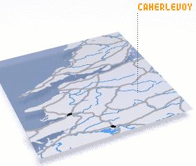 Places with similar names to Caherlevoy, Ireland ::
// Kharaylovo (RU)
// Kharlovo (RU)
// Kharlovo (RU)
// Kharlovo (RU)
// Kharlovo (RU)
// Khorlovo (RU)
// Khorlovo (RU)
// (( Kharlovo )) (RU)
Disclaimer :: Information on this page comes without warranty of any kind |
||
|
Where is Caherlevoy? Elevation and coordinates ::
Latitude (lat): 52°20'3"N Longitude (lon): 9°12'36"W
Elevation (approx.): 249m (map arrows pan, magnifying glasses zoom) |
||
|
Visiting Caherlevoy? Hotel/Accommodation ::
Book a hotel in Caherlevoy Travel Guide ::
Buy a travel guide for Ireland rental cars ::
car rental offers GPS waypoint ::
download a GPX waypoint (PoI) of Caherlevoy for your GPS receiver
|
||