|
search place name
|
||
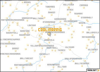
Coolinarrig (Cill Mhantáin, Ireland)Coolinarrig is a town in the Cill Mhantáin region of Ireland. An overview map of the region around Coolinarrig is displayed below.
regional and 3d topo map of Coolinarrig, Ireland ::
Coolinarrig airports ::
The nearest airport is DUB - Dublin, located 59.3 km north east of Coolinarrig.
Other airports nearby include WAT - Waterford (89.1 km south), ENK - Enniskillen St Angelo (174.0 km north), ORK - Cork (174.5 km south west), BFS - Belfast Aldergrove (192.7 km north), Nearby towns ::
Boley (1.0km south west) //
Spinans Cross Roads (1.2km north east) //
Saundersville (2.2km north) //
Woodfield (2.4km south) //
Tuckmill (2.2km north west) //
Eldon Bridge (2.1km north west) //
Rathcoran (2.1km west) //
Rathmagree (2.4km west) //
Baltinglass (2.6km south west) //
Bealach Conglais (2.6km south west) //
Waterloo Bridge (3.9km north) //
Áth na Sráide (4.3km north) //
Stratford (4.3km north) //
Clogh (3.9km south west) //
Bawnoge (3.4km south west) //
Mount Slaney (4.0km north east) //
Talbotstown (3.5km south east) //
Mount Neill (5.3km south) //
Yellowford Cross Roads (4.9km south) //
Mountkelly (5.5km south) //
Rampere Cross Roads (3.8km north west) //
Donaghmore (5.9km north east) //
Hartstown (4.5km north west) //
Freynestown (6.9km north) //
Kelshabeg (4.5km east) //
Davidstown (5.6km north east) //
Ballyhook (6.2km north west) //
Lowtown (5.1km north west) //
Tiknock (6.7km south east) //
[all distances 'as the bird flies' and approximate] 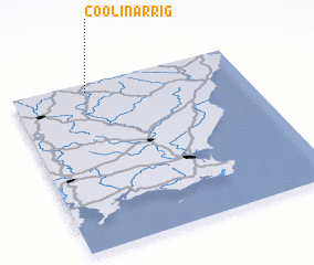 Places with similar names to Coolinarrig, Ireland ::
// Kolonie Erika (DE)
// Kolonia Raków (PL)
// Kolonia Raków (PL)
// Kolonia Ryki (PL)
// Gleneric (ZA)
// Glenrock (US)
// Glen Rock (US)
// Glen Rock (US)
// Glen Rock (US)
// Glen Rock (US)
Disclaimer :: Information on this page comes without warranty of any kind |
||
|
Where is Coolinarrig? Elevation and coordinates ::
Latitude (lat): 52°56'50"N Longitude (lon): 6°40'28"W
Elevation (approx.): 297m (map arrows pan, magnifying glasses zoom) |
||
|
Visiting Coolinarrig? Hotel/Accommodation ::
Book a hotel in Coolinarrig Travel Guide ::
Buy a travel guide for Ireland rental cars ::
car rental offers GPS waypoint ::
download a GPX waypoint (PoI) of Coolinarrig for your GPS receiver
|
||