|
search place name
|
||
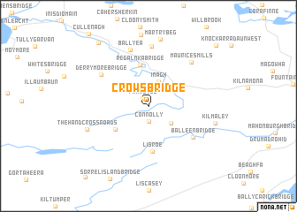
Crowʼs Bridge (An Clár, Ireland)Crowʼs Bridge is a town in the An Clár region of Ireland. An overview map of the region around Crowʼs Bridge is displayed below.
regional and 3d topo map of Crowʼs Bridge, Ireland ::
Crowʼs Bridge airports ::
The nearest airport is SNN - Shannon, located 24.3 km south east of Crowʼs Bridge.
Other airports nearby include GWY - Galway (53.1 km north), KIR - Kerry (77.5 km south), NOC - Connaught (120.9 km north), ORK - Cork (121.8 km south east), Nearby towns ::
Farmoyle (1.1km north west) //
Connolly (2.0km south) //
Inagh (3.2km north) //
Aughaglanna Bridge (2.8km south east) //
Glen Bridge (3.9km south west) //
Regalnka Bridge (5.2km north) //
Lisroe (5.8km south) //
Balleen Bridge (5.2km south east) //
Derrymore Bridge (5.3km north west) //
Ballyea (7.2km north) //
Shanweela (7.5km north) //
Mauricesmills (6.4km north east) //
The Hand Cross Roads (5.6km south west) //
Martrybeg (8.4km north) //
Kilmaley (5.5km south east) //
Ballyvramneen (8.8km north west) //
Knockarradaun East (9.3km north east) //
[all distances 'as the bird flies' and approximate] 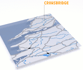 Places with similar names to Crowʼs Bridge, Ireland ::
// Groß Berge (DE)
// Goresbridge (IE)
Disclaimer :: Information on this page comes without warranty of any kind |
||
|
Where is Crowʼs Bridge? Elevation and coordinates ::
Latitude (lat): 52°50'51"N Longitude (lon): 9°11'37"W
Elevation (approx.): 85m (map arrows pan, magnifying glasses zoom) |
||
|
Visiting Crowʼs Bridge? Hotel/Accommodation ::
Book a hotel in Crowʼs Bridge Travel Guide ::
Buy a travel guide for Ireland rental cars ::
car rental offers GPS waypoint ::
download a GPX waypoint (PoI) of Crowʼs Bridge for your GPS receiver
|
||