|
search place name
|
||
Gortnahoo (Tiobraid Árann, Ireland)Gortnahoo is a town in the Tiobraid Árann region of Ireland. An overview map of the region around Gortnahoo is displayed below.
regional and 3d topo map of Gortnahoo, Ireland ::

Gortnahoo airports ::
The nearest airport is WAT - Waterford, located 64.7 km south east of Gortnahoo.
Other airports nearby include SNN - Shannon (89.7 km west), ORK - Cork (111.1 km south west), GWY - Galway (113.8 km north west), DUB - Dublin (121.7 km north east), Nearby towns ::
Rathbeg Bridge (1.1km north east) //
Tranagh (2.0km north) //
Graiguepadeen (3.0km north west) //
Longfordpass Bridge (3.1km north west) //
Ballysloe (4.3km south) //
Urlingford (5.0km north) //
Áth na nUrlainn (5.0km north) //
Tincashel Cross Roads (4.3km north east) //
Grange (3.9km south east) //
Islands (6.4km north) //
Lisduff Bridge (4.5km east) //
Coalbrook (7.1km south) //
Renaghmore (5.2km south east) //
Longfordpass North (5.6km north west) //
New Birmingham (7.3km south) //
Commons (6.7km south east) //
Baile Sheáin (8.6km north) //
Johnstown (8.6km north) //
Sevensisters (7.9km north east) //
Balief Cross Roads (7.4km north east) //
[all distances 'as the bird flies' and approximate] 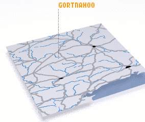 Places with similar names to Gortnahoo, Ireland ::
Disclaimer :: Information on this page comes without warranty of any kind |
||
|
Where is Gortnahoo? Elevation and coordinates ::
Latitude (lat): 52°40'36"N Longitude (lon): 7°35'57"W
Elevation (approx.): 140m (map arrows pan, magnifying glasses zoom) |
||
|
Visiting Gortnahoo? Hotel/Accommodation ::
Book a hotel in Gortnahoo Travel Guide ::
Buy a travel guide for Ireland rental cars ::
car rental offers GPS waypoint ::
download a GPX waypoint (PoI) of Gortnahoo for your GPS receiver
|
||