|
search place name
|
||
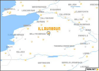
Illaunbaun (An Clár, Ireland)Illaunbaun is a town in the An Clár region of Ireland. An overview map of the region around Illaunbaun is displayed below.
regional and 3d topo map of Illaunbaun, Ireland ::
Illaunbaun airports ::
The nearest airport is SNN - Shannon, located 32.1 km south east of Illaunbaun.
Other airports nearby include GWY - Galway (54.4 km north east), KIR - Kerry (77.6 km south), NOC - Connaught (120.8 km north), ORK - Cork (127.2 km south east), Nearby towns ::
Whiteʼs Bridge (2.4km north) //
Cloghannmore (2.1km south west) //
Fahanlunaghta Bridge (2.4km north east) //
Ballynew Bridge (2.6km west) //
Moy More (4.5km north west) //
Tullygarvan (5.4km north) //
Hoganʼs Bridge (4.7km south west) //
The Hand Cross Roads (6.2km south east) //
Derrymore Bridge (4.9km east) //
An Leacht (8.0km north) //
Lehinch (8.0km north) //
Rinneen (5.6km north west) //
Inis Díomáin (8.8km north) //
Ennistimon (8.8km north) //
Cullenagh (7.8km north east) //
Ballyvramneen (7.2km north east) //
Moyglass Bridge (8.5km south west) //
Drehidnaraga Bridge (8.1km south west) //
Liscannor (9.6km north west) //
Lios Ceannúir (9.6km north west) //
[all distances 'as the bird flies' and approximate]  Places with similar names to Illaunbaun, Ireland ::
// Illanbaun (IE)
Disclaimer :: Information on this page comes without warranty of any kind |
||
|
Where is Illaunbaun? Elevation and coordinates ::
Latitude (lat): 52°52'0"N Longitude (lon): 9°18'55"W
Elevation (approx.): 210m (map arrows pan, magnifying glasses zoom) |
||
|
Visiting Illaunbaun? Hotel/Accommodation ::
Book a hotel in Illaunbaun Travel Guide ::
Buy a travel guide for Ireland rental cars ::
car rental offers GPS waypoint ::
download a GPX waypoint (PoI) of Illaunbaun for your GPS receiver
|
||