|
search place name
|
||
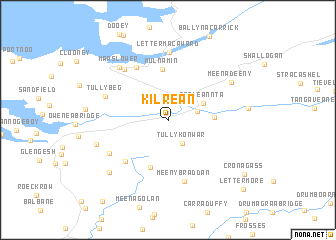
Kilrean (Donegal, Ireland)Kilrean is a town in the Donegal region of Ireland. An overview map of the region around Kilrean is displayed below.
regional and 3d topo map of Kilrean, Ireland ::
Kilrean airports ::
The nearest airport is SXL - Sligo, located 58.6 km south of Kilrean.
Other airports nearby include ENK - Enniskillen St Angelo (60.5 km south east), LDY - Londonderry Eglinton (79.7 km east), NOC - Connaught (102.2 km south), GWY - Galway (169.8 km south), Nearby towns ::
Tullykonwar (2.7km south) //
Mullenieran Bridge (2.1km north east) //
Glenties (2.9km north east) //
Na Gleannta (2.9km north east) //
Meenachallow (3.0km east) //
Crocknagapple (5.4km south) //
Mulnamin (5.7km north) //
Ardvally (5.3km south west) //
Maas Upper (6.2km north) //
Meenybraddan (6.8km south) //
Tully Beg (4.8km north west) //
Maas (6.4km north west) //
Lettermacaward (7.5km north) //
Leitir Mhic an Bhaird (7.5km north) //
Cronkeeran (5.3km south west) //
Maas Lower (6.7km north west) //
Meenadeeny (5.8km north east) //
Monargan Glebe (5.4km south west) //
Altnagapple (6.9km south west) //
Mullanmore (5.3km east) //
Cronagass (7.8km south east) //
Lettermore (9.1km south east) //
[all distances 'as the bird flies' and approximate] 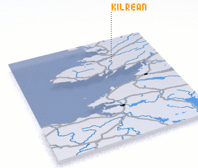 Places with similar names to Kilrean, Ireland ::
Disclaimer :: Information on this page comes without warranty of any kind |
||
|
Where is Kilrean? Elevation and coordinates ::
Latitude (lat): 54°46'50"N Longitude (lon): 8°19'3"W
Elevation (approx.): 44m (map arrows pan, magnifying glasses zoom) |
||
|
Visiting Kilrean? Hotel/Accommodation ::
Book a hotel in Kilrean Travel Guide ::
Buy a travel guide for Ireland rental cars ::
car rental offers GPS waypoint ::
download a GPX waypoint (PoI) of Kilrean for your GPS receiver
|
||