|
search place name
|
||
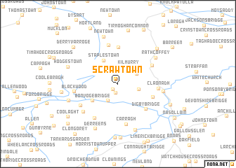
Scrawtown (Cill Dara, Ireland)Scrawtown is a town in the Cill Dara region of Ireland. An overview map of the region around Scrawtown is displayed below.
regional and 3d topo map of Scrawtown, Ireland ::
Scrawtown airports ::
The nearest airport is DUB - Dublin, located 34.6 km north east of Scrawtown.
Other airports nearby include WAT - Waterford (125.7 km south), ENK - Enniskillen St Angelo (136.2 km north west), BFS - Belfast Aldergrove (155.3 km north), BHD - Belfast City (157.7 km north), Nearby towns ::
Prosperous (1.0km south west) //
An Chorrchoill (1.0km south west) //
The Hutters Cross Roads (1.4km south) //
Kilmurry (2.8km north) //
Goatstown (2.8km south) //
Belaghstown Cross Roads (2.3km north east) //
Firmount Cross Roads (2.2km south east) //
Mainham (2.6km north east) //
Staplestown (4.0km north) //
Bonvoge Bridge (3.6km south west) //
Donadea (5.8km north) //
Millicent Cross Roads (3.9km south east) //
Digby Bridge (4.8km south east) //
Boherhole Cross Roads (4.4km north east) //
Ballagh Cross Roads (6.2km north) //
Clane (3.9km east) //
Claonadh (3.9km east) //
Carragh (6.5km south) //
Oldtowndonore (5.9km south) //
Mylerstown (4.9km south west) //
Blackwood (4.3km west) //
Newtowndonore (5.6km south west) //
Alexandra Bridge (4.5km east) //
Rathcoffey (5.5km north east) //
Newtown (7.7km north) //
Carragh Bridge (7.6km south) //
Derreens (7.5km south) //
Robertstown (5.4km south west) //
Baile Riobaird (5.4km south west) //
[all distances 'as the bird flies' and approximate] 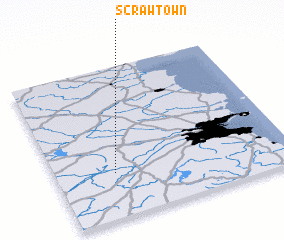 Places with similar names to Scrawtown, Ireland ::
// Zagorodnyy (RU)
// Zagorodnyy (RU)
// Screeton (US)
// Scharten (AT)
// Scharten (AT)
// Scharten (AT)
// Schratten (AT)
// Schrötten (AT)
// Secret Town (US)
// Sugarton (US)
Disclaimer :: Information on this page comes without warranty of any kind |
||
|
Where is Scrawtown? Elevation and coordinates ::
Latitude (lat): 53°17'53"N Longitude (lon): 6°44'50"W
Elevation (approx.): 86m (map arrows pan, magnifying glasses zoom) |
||
|
Visiting Scrawtown? Hotel/Accommodation ::
Book a hotel in Scrawtown Travel Guide ::
Buy a travel guide for Ireland rental cars ::
car rental offers GPS waypoint ::
download a GPX waypoint (PoI) of Scrawtown for your GPS receiver
|
||