|
search place name
|
||
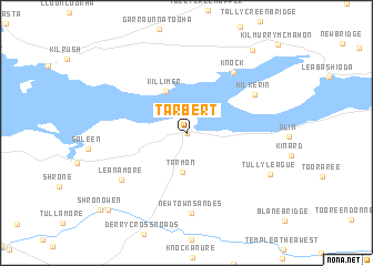
Tarbert (Ciarraí, Ireland)Tarbert is a town in the Ciarraí region of Ireland. An overview map of the region around Tarbert is displayed below.
regional and 3d topo map of Tarbert, Ireland ::
Tarbert airports ::
The nearest airport is SNN - Shannon, located 33.7 km north east of Tarbert.
Other airports nearby include KIR - Kerry (44.8 km south), GWY - Galway (86.0 km north), ORK - Cork (101.4 km south east), NOC - Connaught (153.4 km north), Nearby towns ::
Tairbeart (0.0km north) //
Tarmon (3.9km south) //
Killimer (4.4km north) //
Knock (6.8km north east) //
Kilkerin (5.6km north east) //
Newtown Sandes (8.0km south) //
Maigh Mheáin (8.0km south) //
Leanamore (6.1km south west) //
Tullyleague (6.5km south east) //
Aughanloge Bridge (9.3km north east) //
Gabbettʼs Bridge (9.1km south west) //
Shronowen (9.3km south west) //
[all distances 'as the bird flies' and approximate] 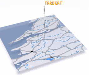 Places with similar names to Tarbert, Ireland ::
// Ytre Byrte (NO)
// Tribierto (ES)
// Drybread (NZ)
// Dārbārūd (IR)
// Dar-e Bord (IR)
// Torbert (US)
// Torbert (US)
// Torre Beretti (IT)
// Tairbeart (IE)
// Douar Bredeah (DZ)
Disclaimer :: Information on this page comes without warranty of any kind |
||
|
Where is Tarbert? Elevation and coordinates ::
Latitude (lat): 52°34'22"N Longitude (lon): 9°22'31"W
Elevation (approx.): 10m (map arrows pan, magnifying glasses zoom) |
||
|
Visiting Tarbert? Hotel/Accommodation ::
Book a hotel in Tarbert Travel Guide ::
Buy a travel guide for Ireland rental cars ::
car rental offers GPS waypoint ::
download a GPX waypoint (PoI) of Tarbert for your GPS receiver
|
||