|
search place name
|
||
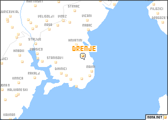
Drenje (Istarska Županija, Croatia)Drenje is a town in the Istarska Županija region of Croatia. An overview map of the region around Drenje is displayed below.
regional and 3d topo map of Drenje, Croatia ::
Drenje airports ::
The nearest airport is PUY - Pula, located 22.7 km south west of Drenje.
Other airports nearby include RJK - Rijeka (39.8 km north east), POW - Portoroz (65.6 km north west), TRS - Ronchi De Legionari Ronchi Dei Legionari (104.3 km north west), LJU - Ljubliana Ljubljana (136.1 km north), Nearby towns ::
Ravni (2.8km south east) //
Škvaranska (3.6km south) //
(( Hrvatini )) (3.7km north) //
Skitača (4.2km south) //
Koromačno (4.7km south west) //
Viskovići (4.4km south west) //
Diminići (4.7km south west) //
Brovinje (5.9km south) //
Stanišovi (4.5km west) //
Rabac (6.8km north) //
Labin (8.8km north) //
Krapan (8.7km north west) //
Vinež (9.4km north) //
Raša (8.8km north west) //
VeliGolji (10.5km north west) //
[all distances 'as the bird flies' and approximate] 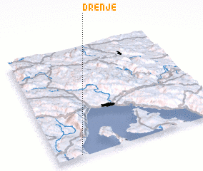 Places with similar names to Drenje, Croatia ::
Disclaimer :: Information on this page comes without warranty of any kind |
||
|
Where is Drenje? Elevation and coordinates ::
Latitude (lat): 45°1'8"N Longitude (lon): 14°8'55"E
Elevation (approx.): 148m (map arrows pan, magnifying glasses zoom) |
||
|
Visiting Drenje? Hotel/Accommodation ::
Book a hotel in Drenje Travel Guide ::
Buy a travel guide for Croatia rental cars ::
car rental offers GPS waypoint ::
download a GPX waypoint (PoI) of Drenje for your GPS receiver
|
||