|
search place name
|
||
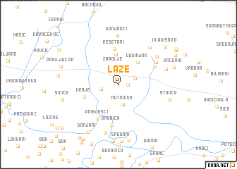
Laze (Croatia)Laze is a town in Croatia. An overview map of the region around Laze is displayed below.
regional and 3d topo map of Laze, Croatia ::
Laze airports ::
The nearest airport is OSI - Osijek, located 109.0 km east of Laze.
Other airports nearby include ZAG - Zagreb (124.7 km north west), SJJ - Sarajevo (168.1 km south east), MBX - Maribor (198.1 km north west), SPU - Split (207.3 km south west), Nearby towns ::
Donji Crnogovci (1.0km east) //
Gornji Crnogovci (2.1km north east) //
Bodovaljci (2.1km west) //
Zapolje (3.0km north) //
Mutničko (3.2km south) //
Godinjak (4.1km north east) //
Adžamovci (4.7km north) //
Rešetari (5.7km north) //
Vrbje (4.3km south west) //
Pribješci (5.9km south west) //
Staro Petrovo Selo (5.0km north east) //
Orubica (6.4km south) //
Trnačani (5.5km north east) //
Oštri Vrh (6.1km north east) //
Tisovac (6.8km north east) //
Gunjavci (7.8km north) //
Orubica (7.7km south) //
Paklenik (5.8km north east) //
Štivica (6.2km south east) //
Donjani (8.3km south west) //
Donjani (8.9km south) //
Krčenik (6.7km north east) //
Sičice (6.7km west) //
Vladisovo (8.0km north east) //
Donja Dolina (9.5km south west) //
Franića Šor (9.5km south west) //
[all distances 'as the bird flies' and approximate]  Places with similar names to Laze, Croatia ::
Disclaimer :: Information on this page comes without warranty of any kind |
||
|
Where is Laze? Elevation and coordinates ::
Latitude (lat): 45°12'19"N Longitude (lon): 17°28'6"E
Elevation (approx.): 97m (map arrows pan, magnifying glasses zoom) |
||
|
Visiting Laze? Hotel/Accommodation ::
Book a hotel in Laze Travel Guide ::
Buy a travel guide for Croatia rental cars ::
car rental offers GPS waypoint ::
download a GPX waypoint (PoI) of Laze for your GPS receiver
|
||