|
search place name
|
||
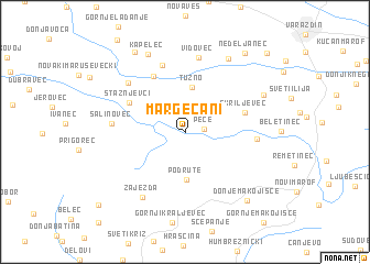
Margečani (Croatia)Margečani is a town in Croatia. An overview map of the region around Margečani is displayed below.
regional and 3d topo map of Margečani, Croatia ::
Margečani airports ::
The nearest airport is MBX - Maribor, located 51.1 km north west of Margečani.
Other airports nearby include ZAG - Zagreb (54.0 km south), GRZ - Graz (105.3 km north west), LJU - Ljubliana Ljubljana (136.7 km west), KLU - Klagenfurt (Worthersee Intl) (152.9 km west), Nearby towns ::
Pece (1.3km east) //
Lovrečan Podbelski (2.9km north east) //
Gačice (2.8km north west) //
Tužno (4.6km north) //
Podrute (4.8km south) //
Škriljevec (4.6km north east) //
Stažnjevci (4.9km north west) //
Selnik Maruševečki (6.1km north) //
Greda Maruševečka (6.9km north) //
Podevčevo (5.0km east) //
Salinovec (5.3km west) //
Cerje Nebojse (6.4km north west) //
Vidovec (7.6km north) //
Zajezda (7.2km south west) //
Zamlačappl (8.1km north) //
Kapelec (8.3km north) //
Beretinec (6.7km north east) //
Donje Makojišće (8.1km south east) //
Maruševec (8.9km north west) //
Nedeljanec (9.0km north east) //
Gornja Selnica (9.5km south west) //
Gojanec (9.8km north east) //
[all distances 'as the bird flies' and approximate]  Places with similar names to Margečani, Croatia ::
Disclaimer :: Information on this page comes without warranty of any kind |
||
|
Where is Margečani? Elevation and coordinates ::
Latitude (lat): 46°12'56"N Longitude (lon): 16°13'45"E
Elevation (approx.): 194m (map arrows pan, magnifying glasses zoom) |
||
|
Visiting Margečani? Hotel/Accommodation ::
Book a hotel in Margečani Travel Guide ::
Buy a travel guide for Croatia rental cars ::
car rental offers GPS waypoint ::
download a GPX waypoint (PoI) of Margečani for your GPS receiver
|
||