|
search place name
|
||
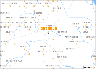
Mostanje (Croatia)Mostanje is a town in Croatia. An overview map of the region around Mostanje is displayed below.
regional and 3d topo map of Mostanje, Croatia ::
Mostanje airports ::
The nearest airport is ZAG - Zagreb, located 48.6 km north east of Mostanje.
Other airports nearby include RJK - Rijeka (83.5 km west), MBX - Maribor (111.2 km north), LJU - Ljubliana Ljubljana (119.1 km north west), PUY - Pula (144.9 km south west), Nearby towns ::
Gradac (1.9km north) //
Karlovac (1.5km west) //
Turan (2.3km south east) //
Mala Švarča (2.3km south west) //
Vodostaj (2.7km north east) //
Dubovac (3.2km north west) //
Novaki (4.5km north west) //
Kamensko (3.9km east) //
Belaj (5.7km south) //
Donje Pokuplje (6.1km north) //
Cerovac Tušilovićki (6.5km south east) //
Podvožić (7.5km south) //
Vučjak (5.5km west) //
Brdo (6.8km north west) //
Mahično (7.8km north) //
Cerovac Barilovički (7.9km south) //
Ladvenjak (7.9km south) //
Galović-Selo (9.1km south west) //
Duga Resa (8.6km south west) //
[all distances 'as the bird flies' and approximate] 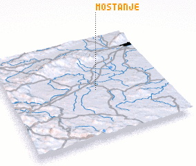 Places with similar names to Mostanje, Croatia ::
Disclaimer :: Information on this page comes without warranty of any kind |
||
|
Where is Mostanje? Elevation and coordinates ::
Latitude (lat): 45°29'0"N Longitude (lon): 15°34'0"E
Elevation (approx.): 109m (map arrows pan, magnifying glasses zoom) |
||
|
Visiting Mostanje? Hotel/Accommodation ::
Book a hotel in Mostanje Travel Guide ::
Buy a travel guide for Croatia rental cars ::
car rental offers GPS waypoint ::
download a GPX waypoint (PoI) of Mostanje for your GPS receiver
|
||