|
search place name
|
||
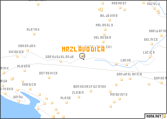
Mrzla Vodica (Primorsko-Goranska Županija, Croatia)Mrzla Vodica is a town in the Primorsko-Goranska Županija region of Croatia. An overview map of the region around Mrzla Vodica is displayed below.
regional and 3d topo map of Mrzla Vodica, Croatia ::
Mrzla Vodica airports ::
The nearest airport is RJK - Rijeka, located 18.4 km south west of Mrzla Vodica.
Other airports nearby include PUY - Pula (78.7 km south west), POW - Portoroz (82.8 km west), LJU - Ljubliana Ljubljana (96.3 km north), TRS - Ronchi De Legionari Ronchi Dei Legionari (106.0 km north west), Nearby towns ::
Zelin Mrzlovodički (2.6km north east) //
Gornje Jelenje (3.7km west) //
Vela Voda (5.0km north east) //
Benkovac Fužinski (7.1km south) //
Crni Lug (6.5km north east) //
Homer (5.2km east) //
Malo Selo (7.6km north east) //
Zlobin (8.4km south) //
Ostrovica (6.8km south west) //
Vrata (7.5km south east) //
Fužine (8.2km south east) //
Belo Selo (7.4km south east) //
Pirovište (10.4km south east) //
Meja Gaj (10.5km south west) //
[all distances 'as the bird flies' and approximate] 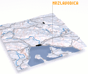 Places with similar names to Mrzla Vodica, Croatia :: Disclaimer :: Information on this page comes without warranty of any kind |
||
|
Where is Mrzla Vodica? Elevation and coordinates ::
Latitude (lat): 45°22'9"N Longitude (lon): 14°39'47"E
Elevation (approx.): 820m (map arrows pan, magnifying glasses zoom) |
||
|
Visiting Mrzla Vodica? Hotel/Accommodation ::
Book a hotel in Mrzla Vodica Travel Guide ::
Buy a travel guide for Croatia rental cars ::
car rental offers GPS waypoint ::
download a GPX waypoint (PoI) of Mrzla Vodica for your GPS receiver
|
||