|
search place name
|
||
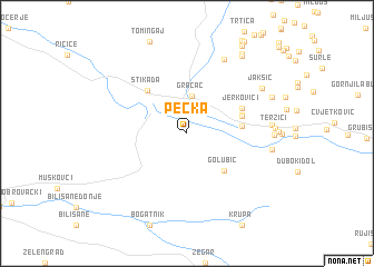
Pecka (Croatia)Pecka is a town in Croatia. An overview map of the region around Pecka is displayed below.
regional and 3d topo map of Pecka, Croatia ::
Pecka airports ::
The nearest airport is ZAD - Zadar, located 43.9 km south west of Pecka.
Other airports nearby include SPU - Split (88.5 km south east), RJK - Rijeka (146.4 km north west), ZAG - Zagreb (165.0 km north), PUY - Pula (168.2 km north west), Nearby towns ::
Gračac (3.8km north) //
Golubić (4.6km south east) //
Javorovići (4.0km east) //
Radusini (4.3km north east) //
Štikada (5.2km north west) //
Grab (4.4km north east) //
Jerkovići (4.7km north east) //
Deringaj (7.9km north) //
Kesići (6.2km east) //
Vučjak (6.3km east) //
Saveri (6.3km east) //
Jakšić (7.1km north east) //
Terzići (6.4km east) //
Mijakovič (7.1km north east) //
Kolundžići (8.7km north east) //
Jelače (8.9km north east) //
Surle (9.6km north east) //
[all distances 'as the bird flies' and approximate]  Places with similar names to Pecka, Croatia ::
Disclaimer :: Information on this page comes without warranty of any kind |
||
|
Where is Pecka? Elevation and coordinates ::
Latitude (lat): 44°16'0"N Longitude (lon): 15°51'0"E
Elevation (approx.): 1031m (map arrows pan, magnifying glasses zoom) |
||
|
Visiting Pecka? Hotel/Accommodation ::
Book a hotel in Pecka Travel Guide ::
Buy a travel guide for Croatia rental cars ::
car rental offers GPS waypoint ::
download a GPX waypoint (PoI) of Pecka for your GPS receiver
|
||