|
search place name
|
||
Račja Vas (Istarska Županija, Croatia)Račja Vas is a town in the Istarska Županija region of Croatia. An overview map of the region around Račja Vas is displayed below.
regional and 3d topo map of Račja Vas, Croatia ::

Račja Vas airports ::
The nearest airport is POW - Portoroz, located 37.2 km west of Račja Vas.
Other airports nearby include RJK - Rijeka (44.7 km south east), PUY - Pula (61.1 km south), TRS - Ronchi De Legionari Ronchi Dei Legionari (65.1 km north west), LJU - Ljubliana Ljubljana (92.7 km north), Nearby towns ::
Rašpor (1.2km north west) //
Prapoće (1.1km west) //
Podgaće (2.4km south east) //
Trstenik (3.0km north west) //
Klenovšćak (2.8km west) //
Lanišće (3.5km south east) //
Roč (5.3km south west) //
Dane (5.7km north west) //
Gornja Nugla (5.0km south west) //
Vodice (6.4km north west) //
Semić (7.1km south) //
Ciritež (6.0km south west) //
Blatna Vas (6.9km south west) //
Poljane (8.5km north) //
Brgudac (7.2km south east) //
Lupoglav (8.9km south) //
Male Mune (6.7km north east) //
Kotli (9.0km south west) //
Jelovice (9.4km north west) //
[all distances 'as the bird flies' and approximate] 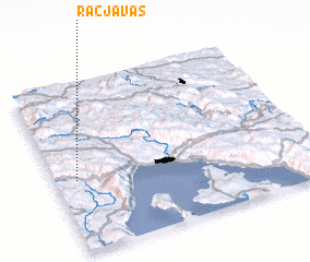 Places with similar names to Račja Vas, Croatia ::
// Regojevići (BA)
Disclaimer :: Information on this page comes without warranty of any kind |
||
|
Where is Račja Vas? Elevation and coordinates ::
Latitude (lat): 45°25'50"N Longitude (lon): 14°5'12"E
Elevation (approx.): 688m (map arrows pan, magnifying glasses zoom) |
||
|
Visiting Račja Vas? Hotel/Accommodation ::
Book a hotel in Račja Vas Travel Guide ::
Buy a travel guide for Croatia rental cars ::
car rental offers GPS waypoint ::
download a GPX waypoint (PoI) of Račja Vas for your GPS receiver
|
||