|
search place name
|
||
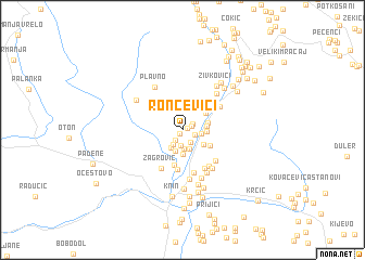
Roncevići (Croatia)Roncevići is a town in Croatia. An overview map of the region around Roncevići is displayed below.
regional and 3d topo map of Roncevići, Croatia ::
Roncevići airports ::
The nearest airport is SPU - Split, located 63.4 km south of Roncevići.
Other airports nearby include ZAD - Zadar (69.1 km west), OMO - Mostar (160.5 km south east), RJK - Rijeka (179.3 km north west), ZAG - Zagreb (182.3 km north), Nearby towns ::
Punoši (0.4km south west) //
Borovići (0.4km north east) //
Radinovići (0.8km north east) //
Lončine (1.0km north east) //
Jerkovići (1.2km south west) //
Reljani (1.1km south east) //
Bubonje (1.4km south east) //
Zelembabe (1.7km south) //
Kablari (1.6km south west) //
Džepine (2.0km south) //
Colaci (1.5km east) //
Arule (2.0km south) //
Golubić (2.1km south west) //
Torlaci (2.2km south) //
Grubići (2.5km south) //
Vukovići (1.8km east) //
Vojnovići (1.8km east) //
Kesići (2.2km south east) //
Dragaši (2.0km east) //
Plavšići (2.5km north east) //
Marići (2.6km south east) //
Bjelje (3.7km south) //
Kulundžije (4.1km south) //
Žagrović (4.3km south) //
Vukovići (3.6km north east) //
Vrpolje (4.3km south) //
Anića Glavica (4.5km south) //
Grgići (4.2km south east) //
Gambiroža (4.0km south east) //
[all distances 'as the bird flies' and approximate]  Places with similar names to Roncevići, Croatia ::
Disclaimer :: Information on this page comes without warranty of any kind |
||
|
Where is Roncevići? Elevation and coordinates ::
Latitude (lat): 44°6'21"N Longitude (lon): 16°12'33"E
Elevation (approx.): 302m (map arrows pan, magnifying glasses zoom) |
||
|
Visiting Roncevići? Hotel/Accommodation ::
Book a hotel in Roncevići Travel Guide ::
Buy a travel guide for Croatia rental cars ::
car rental offers GPS waypoint ::
download a GPX waypoint (PoI) of Roncevići for your GPS receiver
|
||