|
search place name
|
||
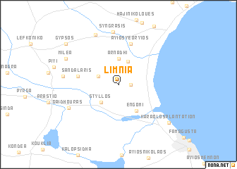
Limnia (Cyprus)Limnia is a town in Cyprus. An overview map of the region around Limnia is displayed below.
regional and 3d topo map of Limnia, Cyprus ::
Limnia airports ::
The nearest airport is LCA - Larnaca, located 41.9 km south west of Limnia.
Other airports nearby include AKT - Akrotiri (104.4 km south west), PFO - Paphos Pafos Intl (136.3 km south west), BEY - Beirut Rafic Hariri Intl (214.0 km south east), ADA - Adana (235.6 km north east), Nearby towns ::
Ayios Seryios (1.5km east) //
Aloa (3.0km north west) //
Styllos (3.6km south west) //
Spathariko (3.9km north) //
Arnadhi (4.2km north) //
Engomi (4.7km south east) //
Sandalaris (5.5km west) //
Ayios Yeoryios (6.7km north) //
Syngrasis (8.4km north) //
Lapathos (8.4km north) //
Gaidhouras (7.4km south west) //
Maratha (7.3km west) //
Milea (8.0km north west) //
Karaolos Plantation (8.8km south east) //
Gypsos (9.4km north west) //
[all distances 'as the bird flies' and approximate] 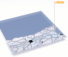 Places with similar names to Limnia, Cyprus ::
Disclaimer :: Information on this page comes without warranty of any kind |
||
|
Where is Limnia? Elevation and coordinates ::
Latitude (lat): 35°12'0"N Longitude (lon): 33°51'30"E
Elevation (approx.): 17m (map arrows pan, magnifying glasses zoom) |
||
|
Visiting Limnia? Hotel/Accommodation ::
Book a hotel in Limnia Travel Guide ::
Buy a travel guide for Cyprus rental cars ::
car rental offers GPS waypoint ::
download a GPX waypoint (PoI) of Limnia for your GPS receiver
|
||