|
search place name
|
||
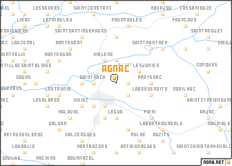
Agnac (Midi-Pyrénées, France)Agnac is a town in the Midi-Pyrénées region of France. An overview map of the region around Agnac is displayed below.
regional and 3d topo map of Agnac, France ::
Agnac airports ::
The nearest airport is RDZ - Rodez Marcillac, located 26.0 km south east of Agnac.
Other airports nearby include AUR - Aurillac (36.4 km north), LBI - Albi Le Sequestre (75.4 km south), BVE - Brive La Roche (89.2 km north west), MEN - Mende Brenoux (101.0 km east), Nearby towns ::
La Borie-de-Pagas (1.3km east) //
Saint-Michel (2.3km south east) //
Saint-Roch (2.6km west) //
Livinhac-le-Haut (2.6km west) //
Agnès (3.7km north) //
Almon-les-Junies (3.2km north east) //
Decazeville (3.9km south) //
Vialene (3.9km north) //
Flagnac (3.9km north) //
Le Crouzet (4.6km south west) //
Le Gua (5.6km south) //
Boisse-Penchot (4.0km west) //
Prayssac (4.0km east) //
La Bessenoits (4.4km south east) //
Aubin (5.7km south) //
Viviez (5.4km south west) //
Saint-Julien-de-Piganiol (7.4km north) //
Cransac (7.5km south) //
Saint-Parthem (6.8km north east) //
Les Bouygues (6.8km north east) //
Firmi (6.8km south east) //
Las Pelies (7.7km north east) //
Malaval (7.7km south west) //
Montmurat (7.7km north west) //
Saint-Santin-de-Maurs (8.4km north west) //
Saint-Santin-Aveyron (8.4km north west) //
La Berthoumarle (9.1km south east) //
[all distances 'as the bird flies' and approximate]  Places with similar names to Agnac, France ::
Disclaimer :: Information on this page comes without warranty of any kind |
||
|
Where is Agnac? Elevation and coordinates ::
Latitude (lat): 44°35'0"N Longitude (lon): 2°16'0"E
Elevation (approx.): 257m (map arrows pan, magnifying glasses zoom) |
||
|
Visiting Agnac? Hotel/Accommodation ::
Book a hotel in Agnac Travel Guide ::
Buy a travel guide for France rental cars ::
car rental offers GPS waypoint ::
download a GPX waypoint (PoI) of Agnac for your GPS receiver
|
||