|
search place name
|
||
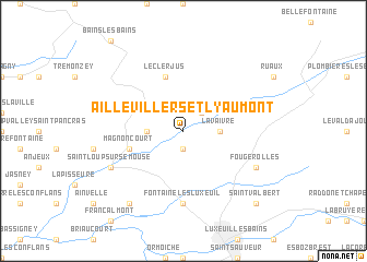
Aillevillers-et-Lyaumont (Franche-Comté, France)Aillevillers-et-Lyaumont is a town in the Franche-Comté region of France. An overview map of the region around Aillevillers-et-Lyaumont is displayed below.
regional and 3d topo map of Aillevillers-et-Lyaumont, France ::
Aillevillers-et-Lyaumont airports ::
The nearest airport is EPL - Epinal Mirecourt, located 49.5 km north west of Aillevillers-et-Lyaumont.
Other airports nearby include CMR - Colmar Houssen (79.5 km east), ENC - Nancy Essey (86.6 km north), MLH - Bale Mulhouse (96.8 km east), DIJ - Dijon Longvic (118.0 km south west), Nearby towns ::
Corbenay (1.9km south) //
La Louvière (2.2km north east) //
Fleurey-lès-Saint-Loup (2.5km west) //
La Vaivre (2.5km east) //
Le Clerjus (5.7km north) //
Magnoncourt (4.2km south west) //
Fontaine-lès-Luxeuil (7.4km south) //
Saint-Loup-sur-Semouse (6.2km south west) //
Fougerolles (6.2km south east) //
Hautevelle (8.3km south west) //
Saint-Valbert (8.9km south east) //
[all distances 'as the bird flies' and approximate] 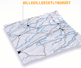 Places with similar names to Aillevillers-et-Lyaumont, France :: Disclaimer :: Information on this page comes without warranty of any kind |
||
|
Where is Aillevillers-et-Lyaumont? Elevation and coordinates ::
Latitude (lat): 47°55'0"N Longitude (lon): 6°20'0"E
Elevation (approx.): 273m (map arrows pan, magnifying glasses zoom) |
||
|
Visiting Aillevillers-et-Lyaumont? Hotel/Accommodation ::
Book a hotel in Aillevillers-et-Lyaumont Travel Guide ::
Buy a travel guide for France rental cars ::
car rental offers GPS waypoint ::
download a GPX waypoint (PoI) of Aillevillers-et-Lyaumont for your GPS receiver
|
||