|
search place name
|
||
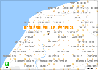
Anglesqueville-lʼ Esneval (Haute-Normandie, France)Anglesqueville-lʼ Esneval is a town in the Haute-Normandie region of France. An overview map of the region around Anglesqueville-lʼ Esneval is displayed below.
regional and 3d topo map of Anglesqueville-lʼ Esneval, France ::
Anglesqueville-lʼ Esneval airports ::
The nearest airport is LEH - Le Havre Octeville, located 15.3 km south west of Anglesqueville-lʼ Esneval.
Other airports nearby include DOL - Deauville St Gatien (30.4 km south), CFR - Caen Carpiquet (71.3 km south west), URO - Rouen Vallee De Seine (73.6 km east), CER - Cherbourg Maupertus (123.1 km west), Nearby towns ::
Turretot (1.9km south) //
Gonneville-la-Mallet (1.2km west) //
Villainville (2.2km north east) //
La Forge (2.4km east) //
Notre-Dame-du-Bec (3.9km south) //
Ecrepintot (3.0km south west) //
Écuquetot (3.9km south) //
Vitreville (3.0km north west) //
Les Châtaigniers (3.0km south east) //
Beaurepaire (3.9km north) //
Criquetot-lʼEsneval (3.0km north east) //
Saint-Martin-du-Bec (4.4km south west) //
Hermeville (4.4km south east) //
Sainte-Marie-au-Bosc (4.4km north west) //
Cuverville (4.4km north east) //
Le Vasseur (5.6km south) //
La Mare Goubert (3.6km west) //
Percoq (3.6km east) //
Épiven (5.6km north) //
Pierrefiques (5.6km north) //
Rolleville (5.7km south) //
Vergetot (4.1km south east) //
Le Parlement (5.7km north) //
Beaumesnil (4.0km north west) //
Mannevillette (5.2km south west) //
Bertrand (6.1km south west) //
Le Tilleul (6.1km north west) //
Pimont (6.1km north west) //
La Poterie-Cap-dʼAntifer (5.2km north west) //
[all distances 'as the bird flies' and approximate] 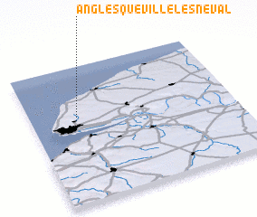 Places with similar names to Anglesqueville-lʼ Esneval, France :: Disclaimer :: Information on this page comes without warranty of any kind |
||
|
Where is Anglesqueville-lʼ Esneval? Elevation and coordinates ::
Latitude (lat): 49°38'0"N Longitude (lon): 0°14'0"W
Elevation (approx.): 122m (map arrows pan, magnifying glasses zoom) |
||
|
Visiting Anglesqueville-lʼ Esneval? Hotel/Accommodation ::
Book a hotel in Anglesqueville-lʼ Esneval Travel Guide ::
Buy a travel guide for France rental cars ::
car rental offers GPS waypoint ::
download a GPX waypoint (PoI) of Anglesqueville-lʼ Esneval for your GPS receiver
|
||