|
search place name
|
||
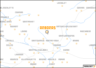
Arboras (Languedoc-Roussillon, France)Arboras is a town in the Languedoc-Roussillon region of France. An overview map of the region around Arboras is displayed below.
regional and 3d topo map of Arboras, France ::
Arboras airports ::
The nearest airport is MPL - Montpellier Mediterranee, located 41.7 km east of Arboras.
Other airports nearby include BZR - Beziers Vias (44.9 km south), FNI - Nimes Garons (75.3 km east), MEN - Mende Brenoux (87.4 km north), DCM - Castres Mazamet (98.0 km west), Nearby towns ::
Saint-Saturnin (2.3km south west) //
Jonquières (3.9km south) //
Montpeyroux (3.9km south) //
Saint-Guiraud (4.6km south west) //
Lagamas (6.2km south east) //
Saint-Jean-de-la-Blaquière (5.7km west) //
Saint-Guilhem-le-Désert (5.7km east) //
Saint-Jean-de-Fos (5.7km east) //
Saint-André-de-Sangonis (7.5km south) //
Saint-Privat (6.5km north west) //
La Vacquerie-et-Saint-Martin-de-Castries (7.9km north) //
Saint-Félix-de-Lodez (7.9km south) //
Lacoste (8.4km south west) //
Saint-Pierre-de-la-Fage (9.1km north west) //
Gignac (9.1km south east) //
[all distances 'as the bird flies' and approximate] 
Disclaimer :: Information on this page comes without warranty of any kind |
||
|
Where is Arboras? Elevation and coordinates ::
Latitude (lat): 43°43'0"N Longitude (lon): 3°29'0"E
Elevation (approx.): 317m (map arrows pan, magnifying glasses zoom) |
||
|
Visiting Arboras? Hotel/Accommodation ::
Book a hotel in Arboras Travel Guide ::
Buy a travel guide for France rental cars ::
car rental offers GPS waypoint ::
download a GPX waypoint (PoI) of Arboras for your GPS receiver
|
||