|
search place name
|
||
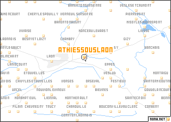
Athies-sous-Laon (Picardie, France)Athies-sous-Laon is a town in the Picardie region of France. An overview map of the region around Athies-sous-Laon is displayed below.
regional and 3d topo map of Athies-sous-Laon, France ::
Athies-sous-Laon airports ::
The nearest airport is RHE - Reims Champagne, located 39.0 km south east of Athies-sous-Laon.
Other airports nearby include CSF - Creil (91.4 km west), CDG - Paris Charles De Gaulle (102.9 km south west), LBG - Paris Le Bourget (112.2 km south west), CRL - Charleroi Brussels South (113.6 km north east), Nearby towns ::
Hainvillers (1.9km north) //
Chambry (4.4km north west) //
Parfondru (4.4km south east) //
Chéret (5.6km south) //
Bruyères-et-Montbérault (5.7km south) //
Samoussy (4.1km north east) //
Orgeval (5.7km south) //
Eppes (4.1km south east) //
Monceau-le-Waast (5.7km north) //
Vorges (6.1km south west) //
Veslud (5.2km south east) //
Laon (4.8km west) //
Montchâlons (6.6km south east) //
Barenton-Bugny (7.8km north) //
Bièvres (7.8km south) //
Presles-et-Thierny (7.4km south west) //
Festieux (7.4km south east) //
Nouvion-le-Vineux (8.8km south west) //
[all distances 'as the bird flies' and approximate]  Places with similar names to Athies-sous-Laon, France :: Disclaimer :: Information on this page comes without warranty of any kind |
||
|
Where is Athies-sous-Laon? Elevation and coordinates ::
Latitude (lat): 49°34'0"N Longitude (lon): 3°41'0"E
Elevation (approx.): 73m (map arrows pan, magnifying glasses zoom) |
||
|
Visiting Athies-sous-Laon? Hotel/Accommodation ::
Book a hotel in Athies-sous-Laon Travel Guide ::
Buy a travel guide for France rental cars ::
car rental offers GPS waypoint ::
download a GPX waypoint (PoI) of Athies-sous-Laon for your GPS receiver
|
||