|
search place name
|
||
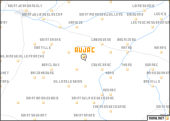
Aujac (Poitou-Charentes, France)Aujac is a town in the Poitou-Charentes region of France. An overview map of the region around Aujac is displayed below.
regional and 3d topo map of Aujac, France ::
Aujac airports ::
The nearest airport is CNG - Cognac Chateaubernard, located 22.2 km south of Aujac.
Other airports nearby include RCO - Rochefort St Agnant (45.5 km west), ANG - Angouleme Brie Champniers (50.2 km east), RYN - Royan Medis (50.9 km south west), NIT - Niort Souche (51.3 km north), Nearby towns ::
Aumagne (1.9km north) //
Authon (2.3km south west) //
Ébéon (3.2km north west) //
Courcerac (3.2km south east) //
La Brousse (4.5km north east) //
Migron (5.6km south) //
Blanzac-lès-Matha (4.3km north east) //
Mons (5.4km south east) //
Villars-les-Bois (6.1km south west) //
Varaize (7.5km north) //
Bercloux (5.5km west) //
Sainte-Même (6.4km north west) //
Le Seure (7.9km south) //
Fontenet (8.4km north west) //
Mesnac (8.4km south east) //
[all distances 'as the bird flies' and approximate] 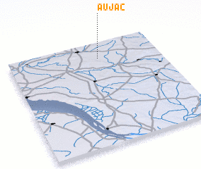 Places with similar names to Aujac, France ::
Disclaimer :: Information on this page comes without warranty of any kind |
||
|
Where is Aujac? Elevation and coordinates ::
Latitude (lat): 45°51'0"N Longitude (lon): 0°24'0"W
Elevation (approx.): 22m (map arrows pan, magnifying glasses zoom) |
||
|
Visiting Aujac? Hotel/Accommodation ::
Book a hotel in Aujac Travel Guide ::
Buy a travel guide for France rental cars ::
car rental offers GPS waypoint ::
download a GPX waypoint (PoI) of Aujac for your GPS receiver
|
||