|
search place name
|
||
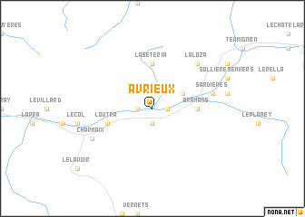
Avrieux (Rhône-Alpes, France)Avrieux is a town in the Rhône-Alpes region of France. An overview map of the region around Avrieux is displayed below.
regional and 3d topo map of Avrieux, France ::
Avrieux airports ::
The nearest airport is TRN - Torino, located 73.3 km east of Avrieux.
Other airports nearby include CMF - Chambery Aix Les Bains (80.5 km north west), NCY - Annecy Meythet (92.7 km north west), CUF - Levaldigi (103.3 km south east), GNB - Grenoble Saint Geoirs (110.0 km west), Nearby towns ::
LʼEsseillon (1.3km east) //
Villarodin-Bourget (1.9km south) //
Bourget (1.3km west) //
Aussois (3.2km north east) //
Bramans (3.9km east) //
La Sétéria (5.6km north) //
Loutra (4.3km south west) //
Modane (4.3km south west) //
Le Verney (5.5km east) //
Sardières (5.5km east) //
La Loza (6.8km north east) //
Fourneaux (6.4km south west) //
Charmaix (6.4km south west) //
[all distances 'as the bird flies' and approximate] 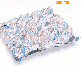 Places with similar names to Avrieux, France ::
// Avaríkos (GR)
Disclaimer :: Information on this page comes without warranty of any kind |
||
|
Where is Avrieux? Elevation and coordinates ::
Latitude (lat): 45°13'0"N Longitude (lon): 6°43'0"E
Elevation (approx.): 1124m (map arrows pan, magnifying glasses zoom) |
||
|
Visiting Avrieux? Hotel/Accommodation ::
Book a hotel in Avrieux Travel Guide ::
Buy a travel guide for France rental cars ::
car rental offers GPS waypoint ::
download a GPX waypoint (PoI) of Avrieux for your GPS receiver
|
||