|
search place name
|
||
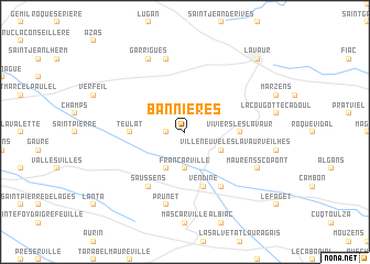
Bannières (Midi-Pyrénées, France)Bannières is a town in the Midi-Pyrénées region of France. An overview map of the region around Bannières is displayed below.
regional and 3d topo map of Bannières, France ::
Bannières airports ::
The nearest airport is TLS - Toulouse Blagnac, located 31.2 km west of Bannières.
Other airports nearby include LBI - Albi Le Sequestre (42.7 km north east), LRH - La Rochelle Lherm (44.4 km south west), DCM - Castres Mazamet (44.4 km east), CCF - Carcassonne Salvaza (64.6 km south east), Nearby towns ::
Montcabrier (1.3km west) //
Belcastel (1.9km north) //
Francarville (3.7km south) //
Villeneuve-lès-Lavaur (3.3km south east) //
Bourg-Saint-Bernard (3.9km south) //
Teulat (4.0km west) //
Viviers-lès-Lavaur (4.0km east) //
Vendine (5.7km south) //
Saussens (6.2km south west) //
Loubens-Lauragais (6.2km south east) //
Prunet (7.5km south) //
Saint-Agnan (7.5km north) //
Maurens-Scopont (6.5km south east) //
Garrigues (7.9km north) //
Lavaur (9.1km north east) //
Labastide-Saint-Georges (9.1km north east) //
[all distances 'as the bird flies' and approximate]  Places with similar names to Bannières, France ::
Disclaimer :: Information on this page comes without warranty of any kind |
||
|
Where is Bannières? Elevation and coordinates ::
Latitude (lat): 43°38'0"N Longitude (lon): 1°45'0"E
Elevation (approx.): 213m (map arrows pan, magnifying glasses zoom) |
||
|
Visiting Bannières? Hotel/Accommodation ::
Book a hotel in Bannières Travel Guide ::
Buy a travel guide for France rental cars ::
car rental offers GPS waypoint ::
download a GPX waypoint (PoI) of Bannières for your GPS receiver
|
||