|
search place name
|
||
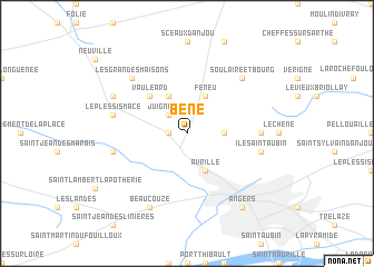
Béné (Pays de la Loire, France)Béné is a town in the Pays de la Loire region of France. An overview map of the region around Béné is displayed below.
regional and 3d topo map of Béné, France ::
Béné airports ::
The nearest airport is CET - Cholet Le Pontreau, located 54.4 km south west of Béné.
Other airports nearby include LVA - Laval Entrammes (56.4 km north), LME - Le Mans Arnage (75.8 km north east), NTE - Nantes Atlantique (87.3 km south west), TUF - Tours Val De Loire (100.7 km east), Nearby towns ::
Montreuil-Belfroy (1.3km west) //
Juigné-Bené (2.2km north west) //
Cantenay-Épinard (2.5km east) //
Avrillé (3.9km south) //
Feneu (3.9km north) //
La Mare (3.9km north) //
Vauléard (4.5km north west) //
Écouflant (5.0km east) //
Île-Saint-Aubin (5.3km east) //
La Meignanne (5.3km west) //
Le Plessis-Macé (5.3km west) //
Soulaire-et-Bourg (6.7km north east) //
Les Grandes Maisons (6.7km north west) //
Pruillé (6.7km north west) //
Beaucouzé (7.8km south) //
La Membrolle-sur-Longuenée (6.2km north west) //
Angers (8.3km south east) //
Sorges (8.3km south east) //
[all distances 'as the bird flies' and approximate] 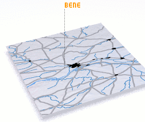 Places with similar names to Béné, France ::
Disclaimer :: Information on this page comes without warranty of any kind |
||
|
Where is Béné? Elevation and coordinates ::
Latitude (lat): 47°32'0"N Longitude (lon): 0°36'0"W
Elevation (approx.): 15m (map arrows pan, magnifying glasses zoom) |
||
|
Visiting Béné? Hotel/Accommodation ::
Book a hotel in Béné Travel Guide ::
Buy a travel guide for France rental cars ::
car rental offers GPS waypoint ::
download a GPX waypoint (PoI) of Béné for your GPS receiver
|
||