|
search place name
|
||
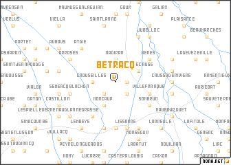
Bétracq (Aquitaine, France)Bétracq is a town in the Aquitaine region of France. An overview map of the region around Bétracq is displayed below.
regional and 3d topo map of Bétracq, France ::
Bétracq airports ::
The nearest airport is PUF - Pau Pyrenees, located 33.5 km south west of Bétracq.
Other airports nearby include LDE - Tarbes Lourdes (37.7 km south), AGF - Agen La Garenne (89.4 km north east), LRH - La Rochelle Lherm (106.5 km east), TLS - Toulouse Blagnac (114.9 km east), Nearby towns ::
Hagedet (1.3km east) //
Monpézat (2.3km south west) //
Lascazères (2.3km south east) //
Madiran (3.7km north) //
Crouseilles (2.7km west) //
Soublecause (3.3km north east) //
Moncaup (3.9km south) //
Villefranque (4.4km south east) //
Héres (5.5km north east) //
Corbères-Abères (6.2km south west) //
Sombrun (5.5km south east) //
Vidouze (7.4km south) //
Lissarre (7.5km south) //
Bassillon-Vauzé (7.5km south) //
Séméacq-Blachon (5.7km west) //
Aydie (6.9km north west) //
Castelnau-Rivière-Basse (7.9km north) //
Arrosés (6.5km north west) //
Lahitte-Toupière (7.9km south) //
Jû-Belloc (8.4km north east) //
Lembeye (8.4km south west) //
Escurès (7.7km south west) //
Larreule (9.2km south east) //
[all distances 'as the bird flies' and approximate]  Places with similar names to Bétracq, France ::
// Bodurağaç (TR)
Disclaimer :: Information on this page comes without warranty of any kind |
||
|
Where is Bétracq? Elevation and coordinates ::
Latitude (lat): 43°31'0"N Longitude (lon): 0°3'0"W
Elevation (approx.): 205m (map arrows pan, magnifying glasses zoom) |
||
|
Visiting Bétracq? Hotel/Accommodation ::
Book a hotel in Bétracq Travel Guide ::
Buy a travel guide for France rental cars ::
car rental offers GPS waypoint ::
download a GPX waypoint (PoI) of Bétracq for your GPS receiver
|
||