|
search place name
|
||
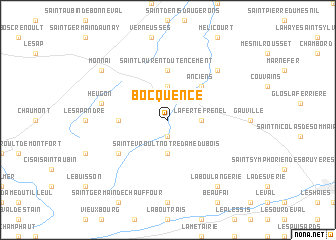
Bocquencé (Basse-Normandie, France)Bocquencé is a town in the Basse-Normandie region of France. An overview map of the region around Bocquencé is displayed below.
regional and 3d topo map of Bocquencé, France ::
Bocquencé airports ::
The nearest airport is DOL - Deauville St Gatien, located 63.4 km north of Bocquencé.
Other airports nearby include CFR - Caen Carpiquet (77.0 km north west), URO - Rouen Vallee De Seine (80.2 km north east), LEH - Le Havre Octeville (82.7 km north), LME - Le Mans Arnage (100.3 km south), Nearby towns ::
La Gonfrière (1.9km south) //
La Ferté-Frênel (2.4km east) //
Saint-Évroult-Notre-Dame-du-Bois (3.7km south) //
Villers-en-Ouche (3.7km north) //
Anciens (4.4km north east) //
Saint-Laurent-du-Tencement (5.6km north) //
Saint-Nicolas-des-Laitiers (3.7km west) //
Touquettes (5.2km south west) //
Heugon (5.2km west) //
Notre-Dame-du-Hamel (6.7km north east) //
La Boulangerie (8.3km south east) //
Monnai (7.4km north west) //
[all distances 'as the bird flies' and approximate]  Places with similar names to Bocquencé, France :: Disclaimer :: Information on this page comes without warranty of any kind |
||
|
Where is Bocquencé? Elevation and coordinates ::
Latitude (lat): 48°50'0"N Longitude (lon): 0°28'0"W
Elevation (approx.): 214m (map arrows pan, magnifying glasses zoom) |
||
|
Visiting Bocquencé? Hotel/Accommodation ::
Book a hotel in Bocquencé Travel Guide ::
Buy a travel guide for France rental cars ::
car rental offers GPS waypoint ::
download a GPX waypoint (PoI) of Bocquencé for your GPS receiver
|
||