|
search place name
|
||
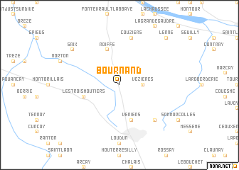
Bournand (Poitou-Charentes, France)Bournand is a town in the Poitou-Charentes region of France. An overview map of the region around Bournand is displayed below.
regional and 3d topo map of Bournand, France ::
Bournand airports ::
The nearest airport is PIS - Poitiers Biard, located 58.1 km south of Bournand.
Other airports nearby include TUF - Tours Val De Loire (63.3 km north east), CET - Cholet Le Pontreau (71.7 km west), NIT - Niort Souche (93.0 km south west), LME - Le Mans Arnage (96.7 km north), Nearby towns ::
 Places with similar names to Bournand, France ::
Disclaimer :: Information on this page comes without warranty of any kind |
||
|
Where is Bournand? Elevation and coordinates ::
Latitude (lat): 47°5'0"N Longitude (lon): 0°4'0"W
Elevation (approx.): 44m (map arrows pan, magnifying glasses zoom) |
||
|
Visiting Bournand? Hotel/Accommodation ::
Book a hotel in Bournand Travel Guide ::
Buy a travel guide for France rental cars ::
car rental offers GPS waypoint ::
download a GPX waypoint (PoI) of Bournand for your GPS receiver
|
||