|
search place name
|
||
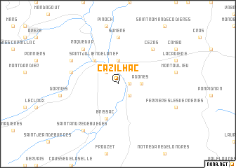
Cazilhac (Languedoc-Roussillon, France)Cazilhac is a town in the Languedoc-Roussillon region of France. An overview map of the region around Cazilhac is displayed below.
regional and 3d topo map of Cazilhac, France ::
Cazilhac airports ::
The nearest airport is MPL - Montpellier Mediterranee, located 42.7 km south east of Cazilhac.
Other airports nearby include FNI - Nimes Garons (59.0 km east), MEN - Mende Brenoux (66.7 km north), BZR - Beziers Vias (72.1 km south west), OBS - Aubenas-vals-lanas Ardeche Meridionale (87.2 km north east), Nearby towns ::
Laroque (1.3km east) //
Ganges (2.3km north west) //
Saint-Bauzille-de-Putois (2.3km south east) //
Agonès (2.7km east) //
Moulès-et-Baucels (3.7km north) //
Saint-Julien-de-la-Nef (4.6km north west) //
Brissac (5.7km south) //
Sumène (7.4km north) //
Saint-Laurent-le-Minier (5.7km west) //
Cézas (6.9km north east) //
Roquedur (6.9km north west) //
Saint-Bresson (6.5km north west) //
Saint-André-de-Buèges (8.4km south west) //
[all distances 'as the bird flies' and approximate] 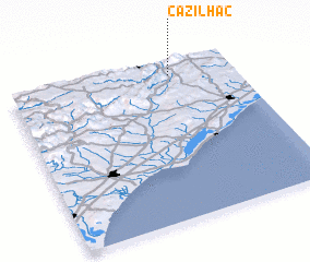 Places with similar names to Cazilhac, France ::
// Cazilhac (FR)
Disclaimer :: Information on this page comes without warranty of any kind |
||
|
Where is Cazilhac? Elevation and coordinates ::
Latitude (lat): 43°55'0"N Longitude (lon): 3°43'0"E
Elevation (approx.): 203m (map arrows pan, magnifying glasses zoom) |
||
|
Visiting Cazilhac? Hotel/Accommodation ::
Book a hotel in Cazilhac Travel Guide ::
Buy a travel guide for France rental cars ::
car rental offers GPS waypoint ::
download a GPX waypoint (PoI) of Cazilhac for your GPS receiver
|
||