|
search place name
|
||
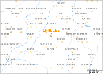
Challes (Rhône-Alpes, France)Challes is a town in the Rhône-Alpes region of France. An overview map of the region around Challes is displayed below.
regional and 3d topo map of Challes, France ::
Challes airports ::
The nearest airport is XBK - Bourg Ceyzeriat, located 15.4 km north west of Challes.
Other airports nearby include GVA - Geneva Cointrin (50.9 km east), LYS - Lyon Saint Exupery (53.8 km south west), NCY - Annecy Meythet (53.9 km south east), QNX - Macon Charnay (54.8 km west), Nearby towns ::
Serrières-sur-Ain (2.3km north west) //
Leyssard (3.7km north) //
Labalme (3.9km south) //
Ceignes (3.2km south east) //
Saint-Alban (3.9km south) //
Cerdon (5.6km south) //
Peyriat (4.3km north east) //
Hautecourt (5.3km north west) //
Romanèche (6.1km north west) //
Meyriat (5.1km west) //
Bolozon (7.5km north) //
Volognat (6.8km north east) //
Mérignat (7.8km south) //
Napt (7.8km north) //
Bohas (6.3km north west) //
Grand-Corent (7.8km north) //
Cize (7.8km north) //
Vieu-dʼIzenave (7.6km south east) //
Poncin (7.6km south west) //
Mornay (8.4km north east) //
[all distances 'as the bird flies' and approximate] 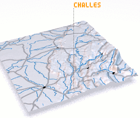 Places with similar names to Challes, France ::
Disclaimer :: Information on this page comes without warranty of any kind |
||
|
Where is Challes? Elevation and coordinates ::
Latitude (lat): 46°8'0"N Longitude (lon): 5°28'0"E
Elevation (approx.): 561m (map arrows pan, magnifying glasses zoom) |
||
|
Visiting Challes? Hotel/Accommodation ::
Book a hotel in Challes Travel Guide ::
Buy a travel guide for France rental cars ::
car rental offers GPS waypoint ::
download a GPX waypoint (PoI) of Challes for your GPS receiver
|
||