|
search place name
|
||
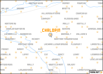
Chalopin (Bourgogne, France)Chalopin is a town in the Bourgogne region of France. An overview map of the region around Chalopin is displayed below.
regional and 3d topo map of Chalopin, France ::
Chalopin airports ::
The nearest airport is AUF - Auxerre Branches, located 54.3 km south of Chalopin.
Other airports nearby include QYR - Troyes Barberey (54.4 km east), ORY - Paris Orly (82.0 km north west), CDG - Paris Charles De Gaulle (94.4 km north west), LBG - Paris Le Bourget (95.5 km north west), Nearby towns ::
Hollard (1.2km east) //
La Garenne (2.2km north east) //
Sergines (3.1km north west) //
Plessis-Saint-Jean (3.9km north) //
La Chapelle-sur-Oreuse (3.9km south) //
Gisy-les-Nobles (4.5km south west) //
Barrault (3.7km east) //
Servins (4.1km north east) //
Compigny (5.7km north) //
Michery (4.1km south west) //
Saint-Martin-sur-Oreuse (4.1km south east) //
Évry (6.1km south west) //
Pailly (5.2km north east) //
Villiers-sur-Terre (7.4km north) //
Cuy (7.5km south) //
La Borde (5.3km east) //
Villeperrot (6.7km south west) //
Montigny-le-Guesdier (7.8km north) //
Soucy (7.8km south) //
Villenavotte (8.3km south west) //
Plessis-du-Mée (7.4km north east) //
[all distances 'as the bird flies' and approximate] 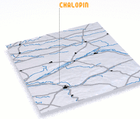 Places with similar names to Chalopin, France ::
Disclaimer :: Information on this page comes without warranty of any kind |
||
|
Where is Chalopin? Elevation and coordinates ::
Latitude (lat): 48°19'0"N Longitude (lon): 3°17'0"E
Elevation (approx.): 162m (map arrows pan, magnifying glasses zoom) |
||
|
Visiting Chalopin? Hotel/Accommodation ::
Book a hotel in Chalopin Travel Guide ::
Buy a travel guide for France rental cars ::
car rental offers GPS waypoint ::
download a GPX waypoint (PoI) of Chalopin for your GPS receiver
|
||