|
search place name
|
||
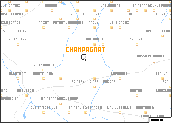
Champagnat (Limousin, France)Champagnat is a town in the Limousin region of France. An overview map of the region around Champagnat is displayed below.
regional and 3d topo map of Champagnat, France ::
Champagnat airports ::
The nearest airport is MCU - Montlucon-gueret Montlucon Gueret, located 23.7 km north of Champagnat.
Other airports nearby include MCU - Montlucon Domerat (43.4 km north east), CFE - Clermont Ferrand Auvergne (73.3 km east), LIG - Limoges Bellegarde (87.3 km west), VHY - Vichy Charmeil (88.3 km east), Nearby towns ::
Saint-Domet (3.9km north) //
Bellegarde-en-Marche (3.9km south) //
La Serre-Bussière-Vieille (4.5km north east) //
Saint-Sylvain-Bellegarde (5.7km south) //
La Chaussade (5.4km south west) //
Saint-Alpinien (5.4km south west) //
Puy-Malsignat (5.5km west) //
Angly (7.5km north) //
Peyrat-la-Nonière (7.8km north) //
Lupersat (6.3km south east) //
Saint-Priest (8.4km north east) //
La Chaud (8.4km north east) //
Le Meignoux (9.0km north east) //
[all distances 'as the bird flies' and approximate]  Places with similar names to Champagnat, France ::
// Champagnat (FR)
Disclaimer :: Information on this page comes without warranty of any kind |
||
|
Where is Champagnat? Elevation and coordinates ::
Latitude (lat): 46°1'0"N Longitude (lon): 2°17'0"E
Elevation (approx.): 537m (map arrows pan, magnifying glasses zoom) |
||
|
Visiting Champagnat? Hotel/Accommodation ::
Book a hotel in Champagnat Travel Guide ::
Buy a travel guide for France rental cars ::
car rental offers GPS waypoint ::
download a GPX waypoint (PoI) of Champagnat for your GPS receiver
|
||