|
search place name
|
||
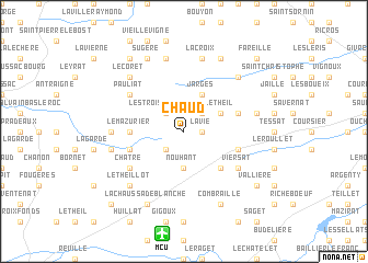
Chaud (Limousin, France)Chaud is a town in the Limousin region of France. An overview map of the region around Chaud is displayed below.
regional and 3d topo map of Chaud, France ::
Chaud airports ::
The nearest airport is MCU - Montlucon-gueret Montlucon Gueret, located 10.6 km south of Chaud.
Other airports nearby include MCU - Montlucon Domerat (15.0 km east), CHR - Chateauroux Deols (78.6 km north west), VHY - Vichy Charmeil (80.4 km east), BOU - Bourges (82.4 km north), Nearby towns ::
La Vie (1.3km east) //
Les Trois Taillants (2.3km north west) //
Le Monceau (2.3km north west) //
Laage (2.3km north east) //
Bellefaye (2.3km south west) //
Nouhant (3.7km south) //
Jarges (3.9km north) //
Frontenat (3.9km north) //
Le Theil (3.2km north east) //
Le Plaix (4.5km south east) //
Le Mazurier (3.8km west) //
Bartillat (4.3km north east) //
La Chassagne (4.3km south west) //
Lamaids (4.3km south east) //
La Valade (5.3km north west) //
Treignat (5.3km north west) //
Pauliat (5.3km north west) //
Châtre (5.3km south west) //
Viersat (5.3km south east) //
Chateux (5.1km west) //
Les Maisons (7.5km north) //
La Croix (7.5km north) //
Soumans (5.4km west) //
Les Montées (5.4km east) //
Le Theillot (6.8km south west) //
Verneiges (6.8km south west) //
Herculat (6.8km north west) //
Le Coret (6.8km north west) //
Le Liat (6.8km north east) //
[all distances 'as the bird flies' and approximate]  Places with similar names to Chaud, France ::
Disclaimer :: Information on this page comes without warranty of any kind |
||
|
Where is Chaud? Elevation and coordinates ::
Latitude (lat): 46°19'0"N Longitude (lon): 2°23'0"E
Elevation (approx.): 498m (map arrows pan, magnifying glasses zoom) |
||
|
Visiting Chaud? Hotel/Accommodation ::
Book a hotel in Chaud Travel Guide ::
Buy a travel guide for France rental cars ::
car rental offers GPS waypoint ::
download a GPX waypoint (PoI) of Chaud for your GPS receiver
|
||