|
search place name
|
||
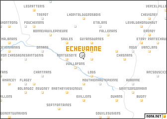
Échevanne (Franche-Comté, France)Échevanne is a town in the Franche-Comté region of France. An overview map of the region around Échevanne is displayed below.
regional and 3d topo map of Échevanne, France ::
Échevanne airports ::
The nearest airport is DLE - Dole Tavaux, located 61.4 km west of Échevanne.
Other airports nearby include DIJ - Dijon Longvic (89.1 km west), GVA - Geneva Cointrin (94.4 km south), BRN - Bern Belp (97.9 km east), QNJ - Annemasse (99.1 km south), Nearby towns ::
Lavans-Vuillafans (1.3km east) //
Durnes (1.9km north) //
Vuillafans (2.2km south west) //
Voires (2.2km north east) //
Montgesoye (2.5km west) //
Lods (3.9km south) //
Guyans-Durnes (3.9km north) //
Saules (4.5km north west) //
Longeville (5.6km south) //
Mouthier-Haute-Pierre (6.1km south east) //
Charbonnières-les-Sapins (7.5km north) //
Vernierfontaine (5.4km east) //
Fallerans (6.7km north east) //
Amathay-Vésigneux (7.8km south) //
Étalans (7.8km north) //
Bonnevaux-le-Prieuré (7.5km north west) //
[all distances 'as the bird flies' and approximate]  Places with similar names to Échevanne, France ::
Disclaimer :: Information on this page comes without warranty of any kind |
||
|
Where is Échevanne? Elevation and coordinates ::
Latitude (lat): 47°5'0"N Longitude (lon): 6°14'0"E
Elevation (approx.): 616m (map arrows pan, magnifying glasses zoom) |
||
|
Visiting Échevanne? Hotel/Accommodation ::
Book a hotel in Échevanne Travel Guide ::
Buy a travel guide for France rental cars ::
car rental offers GPS waypoint ::
download a GPX waypoint (PoI) of Échevanne for your GPS receiver
|
||