|
search place name
|
||
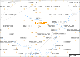
Étavigny (Picardie, France)Étavigny is a town in the Picardie region of France. An overview map of the region around Étavigny is displayed below.
regional and 3d topo map of Étavigny, France ::
Étavigny airports ::
The nearest airport is CDG - Paris Charles De Gaulle, located 33.7 km west of Étavigny.
Other airports nearby include CSF - Creil (37.1 km north west), LBG - Paris Le Bourget (42.9 km west), ORY - Paris Orly (63.1 km south west), POX - Pontoise Cormeilles En Vexin (68.9 km west), Nearby towns ::
Acy-en-Multien (2.2km south west) //
Antilly (3.7km north) //
Réez-Fosse-Martin (3.1km south west) //
Boullarre (3.1km north east) //
Vincy-Manoeuvre (3.9km south) //
Rosoy-en-Multien (3.9km south) //
Betz (4.4km north west) //
Bouillancy (3.6km west) //
Rouvres (3.6km east) //
Le Plessis-Placy (5.7km south) //
Cuvergnon (7.4km north) //
Bargny (7.5km north) //
Trocy-en-Multien (7.5km south) //
Varinfroy (5.2km east) //
Thury-en-Valois (6.6km north east) //
May-en-Multien (6.6km south east) //
Villers-Saint-Genest (6.1km north west) //
Puisieux (7.4km south west) //
[all distances 'as the bird flies' and approximate] 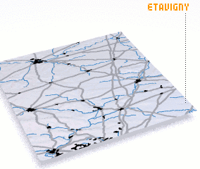 Places with similar names to Étavigny, France :: Disclaimer :: Information on this page comes without warranty of any kind |
||
|
Where is Étavigny? Elevation and coordinates ::
Latitude (lat): 49°7'0"N Longitude (lon): 2°59'0"E
Elevation (approx.): 134m (map arrows pan, magnifying glasses zoom) |
||
|
Visiting Étavigny? Hotel/Accommodation ::
Book a hotel in Étavigny Travel Guide ::
Buy a travel guide for France rental cars ::
car rental offers GPS waypoint ::
download a GPX waypoint (PoI) of Étavigny for your GPS receiver
|
||