|
search place name
|
||
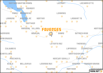
Faverges (Rhône-Alpes, France)Faverges is a town in the Rhône-Alpes region of France. An overview map of the region around Faverges is displayed below.
regional and 3d topo map of Faverges, France ::
Faverges airports ::
The nearest airport is NCY - Annecy Meythet, located 25.3 km north west of Faverges.
Other airports nearby include CMF - Chambery Aix Les Bains (35.0 km west), QNJ - Annemasse (49.2 km north), GVA - Geneva Cointrin (56.2 km north), GNB - Grenoble Saint Geoirs (87.1 km south west), Nearby towns ::
La Balmette (1.3km west) //
Verchères (1.9km south) //
Saint-Ferréol (1.9km north) //
Les Savioz (2.3km north east) //
Cons-Sainte-Colombe (2.6km east) //
Ombre (2.6km east) //
Seythenex (3.7km south) //
Le Tertenoz (3.9km south) //
Les Combes (3.9km south) //
Plan Motmin (4.5km north west) //
Giez (3.9km west) //
Bourjal (3.9km west) //
Villard (4.3km north west) //
Vésonne (4.3km north west) //
Marlens (4.3km north east) //
Montmin (6.1km north west) //
Serraval (6.8km north east) //
La Bottière (7.9km north) //
Le Marais (7.9km north) //
Verthier (6.4km north west) //
La Frasse (7.6km south east) //
Allondaz (7.6km south east) //
Le Bouchet-Mont Charvin (7.6km north east) //
[all distances 'as the bird flies' and approximate]  Places with similar names to Faverges, France ::
// Vaufargis (FR)
Disclaimer :: Information on this page comes without warranty of any kind |
||
|
Where is Faverges? Elevation and coordinates ::
Latitude (lat): 45°45'0"N Longitude (lon): 6°18'0"E
Elevation (approx.): 508m (map arrows pan, magnifying glasses zoom) |
||
|
Visiting Faverges? Hotel/Accommodation ::
Book a hotel in Faverges Travel Guide ::
Buy a travel guide for France rental cars ::
car rental offers GPS waypoint ::
download a GPX waypoint (PoI) of Faverges for your GPS receiver
|
||