|
search place name
|
||
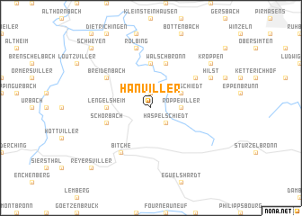
Hanviller (Lorraine, France)Hanviller is a town in the Lorraine region of France. An overview map of the region around Hanviller is displayed below.
regional and 3d topo map of Hanviller, France ::
Hanviller airports ::
The nearest airport is SCN - Saarbruecken Saarbrucken, located 29.0 km north west of Hanviller.
Other airports nearby include RMS - Ramstein Ab (38.7 km north), ZCC - Baden-baden Baden Oos (63.0 km south east), SXB - Strassbourg Entzheim (63.6 km south), ZQC - Speyer (75.2 km east), Nearby towns ::
Bousseviller (1.9km north) //
Haspelschiedt (2.2km south east) //
Roppeviller (2.4km east) //
Liederschiedt (3.1km north east) //
Waldhouse (5.6km north) //
Lengelsheim (3.6km west) //
Walschbronn (5.7km north) //
Schorbach (4.1km south west) //
Schweix (5.2km north east) //
Breidenbach (5.2km north west) //
Bitche (6.1km south west) //
Rolbing (7.5km north) //
Hilst (6.1km north east) //
Kröppen (7.4km north east) //
Reyersviller (8.9km south west) //
Schweyen (8.9km north west) //
[all distances 'as the bird flies' and approximate] 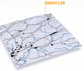
Disclaimer :: Information on this page comes without warranty of any kind |
||
|
Where is Hanviller? Elevation and coordinates ::
Latitude (lat): 49°6'0"N Longitude (lon): 7°28'0"E
Elevation (approx.): 390m (map arrows pan, magnifying glasses zoom) |
||
|
Visiting Hanviller? Hotel/Accommodation ::
Book a hotel in Hanviller Travel Guide ::
Buy a travel guide for France rental cars ::
car rental offers GPS waypoint ::
download a GPX waypoint (PoI) of Hanviller for your GPS receiver
|
||