|
search place name
|
||
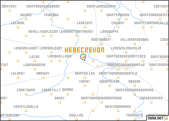
Hébécrevon (Basse-Normandie, France)Hébécrevon is a town in the Basse-Normandie region of France. An overview map of the region around Hébécrevon is displayed below.
regional and 3d topo map of Hébécrevon, France ::
Hébécrevon airports ::
The nearest airport is CFR - Caen Carpiquet, located 52.5 km east of Hébécrevon.
Other airports nearby include CER - Cherbourg Maupertus (61.6 km north), JER - Jersey (75.5 km west), DNR - Dinard Pleurtuit (90.4 km south west), ACI - Alderney (99.2 km north west), Nearby towns ::
Rampan (1.2km east) //
Amigny (2.2km north west) //
Saint-Gilles (3.7km south) //
Le Mesnil-Amey (4.4km south west) //
Pont-Hébert (4.4km north east) //
Canisy (5.6km south) //
La Miquellerie (3.6km west) //
La Chapelle-en-Juger (3.6km west) //
Le Hommet-dʼArthenay (5.7km north) //
Montreuil-sur-Lozon (4.9km west) //
Le Dézert (7.4km north) //
Saint-Ébremond-de-Bonfossé (7.5km south) //
Le Mesnil-Eury (5.2km west) //
Agneaux (5.2km east) //
Gourfaleur (6.6km south east) //
La Meauffe (6.6km north east) //
Quibou (7.8km south) //
Saint-Thomas-de-Saint-Lô (6.1km south east) //
Les Champs-de-Losque (7.4km north west) //
Carantilly (8.9km south west) //
Cavigny (8.9km north east) //
[all distances 'as the bird flies' and approximate]  Places with similar names to Hébécrevon, France :: Disclaimer :: Information on this page comes without warranty of any kind |
||
|
Where is Hébécrevon? Elevation and coordinates ::
Latitude (lat): 49°8'0"N Longitude (lon): 1°10'0"W
Elevation (approx.): 64m (map arrows pan, magnifying glasses zoom) |
||
|
Visiting Hébécrevon? Hotel/Accommodation ::
Book a hotel in Hébécrevon Travel Guide ::
Buy a travel guide for France rental cars ::
car rental offers GPS waypoint ::
download a GPX waypoint (PoI) of Hébécrevon for your GPS receiver
|
||